Bni Bouayach geodata
Bni Bouayach (Tanger-Tetouan-Al Hoceima) is a populated place; located in Morocco in Africa/Casablanca (GMT+1) time zone. With population of 18,271 people, there are 81 cities with bigger population in this country. Compared to other cities in Morocco, 90.3% of cities are located further ↓South; 89.5% of cities are located further ←West and 79.8% of cities have higher elevation than Bni Bouayach. Note1


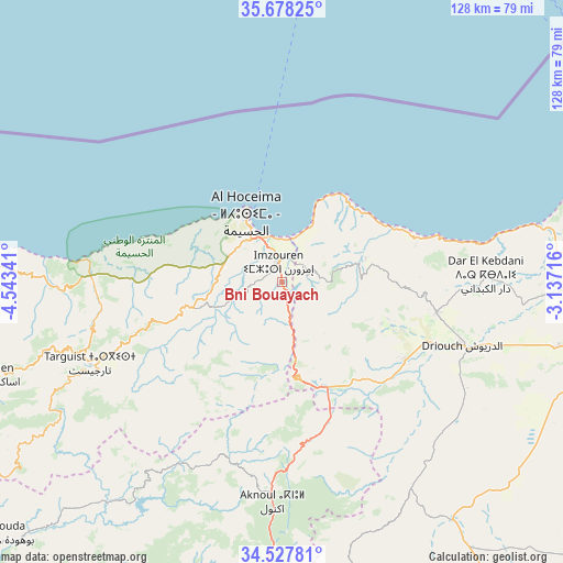
Bni Bouayach GPS coordinates[2]
35° 6' 18.216" North, 3° 50' 25.008" West
| Map corner | latitude | longitude |
|---|---|---|
| Upper-left | 35.67825°, | -4.54341° |
| Center: | 35.10506°, | -3.84028° |
| Lower-right: | 34.52781°, | -3.13716° |
| Map W x H: | 127.9×127.9 km | = 79.5×79.5mi |
| max Lat: | 35.84906° ⇑9.7% North |
| Bni Bouayach: | 35.10506° |
| min Lat: | ⇓90.3% South 22.6558° |
| min Long | Bni Bouayach | max Long |
| -15.60719° | -3.84028° | -1.22855° |
| W 89.5%⇐ | ⇒10.5% E |
Elevation
Elevation of Bni Bouayach is 118 m = 387 ft, and this is 498.8 m = 1636 ft below average elevation for this country.
| Max E: |
2637 m = 8652 ft | 79.8% |
| Avg. | 616.8 m = 2024 ft | |
| Bni Bouayach | 118 m = 387 ft | |
Min E: |
1 m = 3 ft | 20.2% |
See also: Morocco elevation on elevation.city.
Geographical zone
Bni Bouayach is located in North temperate zone (between Tropic of Cancer and the Arctic Circle). Distance of this Northern Tropic circle is 1297.4 km =806.2 mi to South.| Distance of | km | miles | from Bni Bouayach |
|---|---|---|---|
| North Pole | 6103.7 | 3792.7 | to North |
| Arctic Circle | 3497.9 | 2173.5 | to North |
| Tropic Cancer | 1297.4 | 806.2 | to South |
| Equator | 3903.3 | 2425.4 | to South |


Nearby cities:
15 places around Bni Bouayach: (largest is in red/bold)
• Ajdir
42.1 km =26.2 mi,  197°
197°
• Aknoul
50.2 km =31.2 mi,  182°
182°
• Al Aaroui
76.3 km =47.4 mi,  97°
97°
• Al Hoceïma
18.5 km =11.5 mi,  331°
331°
• Boudinar
20.5 km =12.7 mi,  73°
73°
• Imzouren
4.7 km =2.9 mi,  348°
348°
• Midar
33.4 km =20.8 mi,  123°
123°
• Nador
82.7 km =51.4 mi,  85°
85°
• Rouadi
27.2 km =16.9 mi,  278°
278°
• Selouane
81.8 km =50.8 mi, 92°
• Senada
34.3 km =21.3 mi,  264°
264°
• Taouima
83 km =51.6 mi, 88°
• Targuist
47.4 km =29.5 mi,  246°
246°
• Tirhanimîne
17.9 km =11.1 mi,  324°
324°
• Tiztoutine
64.3 km =40 mi, 103°
Sources, notices
• [Note1] Compared only with cities in Morocco existing in our database
• [Src1] Map data: © OpenStreetMap contributors (CC-BY-SA)
• [Src2] Other city data from geonames.org with taken over terms of usage.
• [Src3] Geographical zone / Annual Mean Temperature by Robert A. Rohde @ Wikipedia
