Rouadi geodata
Rouadi (Tanger-Tetouan-Al Hoceima) is a seat of a third-order administrative division; located in Morocco in Africa/Casablanca (GMT+1) time zone. In our database, there are 108 cities with bigger population. Compared to other cities in Morocco, 91.9% of cities are located further ↓South; 86% of cities are located further ←West and 54.3% of cities have higher elevation than Rouadi. Note1


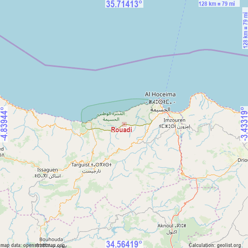
Rouadi GPS coordinates[2]
35° 8' 28.284" North, 4° 8' 10.716" West
| Map corner | latitude | longitude |
|---|---|---|
| Upper-left | 35.71413°, | -4.83944° |
| Center: | 35.14119°, | -4.13631° |
| Lower-right: | 34.56419°, | -3.43319° |
| Map W x H: | 127.9×127.9 km | = 79.5×79.5mi |
| max Lat: | 35.84906° ⇑8.1% North |
| Rouadi: | 35.14119° |
| min Lat: | ⇓91.9% South 22.6558° |
| min Long | Rouadi | max Long |
| -15.60719° | -4.13631° | -1.22855° |
| W 86%⇐ | ⇒14% E |
Elevation
Elevation of Rouadi is 399 m = 1309 ft, and this is 217.8 m = 715 ft below average elevation for this country.
| Max E: |
2637 m = 8652 ft | 54.3% |
| Avg. | 616.8 m = 2024 ft | |
| Rouadi | 399 m = 1309 ft | |
Min E: |
1 m = 3 ft | 45.7% |
See also: Morocco elevation on elevation.city.
Geographical zone
Rouadi is located in North temperate zone (between Tropic of Cancer and the Arctic Circle). Distance of this Northern Tropic circle is 1301.4 km =808.7 mi to South.| Distance of | km | miles | from Rouadi |
|---|---|---|---|
| North Pole | 6099.7 | 3790.2 | to North |
| Arctic Circle | 3493.8 | 2170.9 | to North |
| Tropic Cancer | 1301.4 | 808.7 | to South |
| Equator | 3907.3 | 2427.9 | to South |


Nearby cities:
15 places around Rouadi: (largest is in red/bold)
• Ajdir
46.6 km =29 mi,  161°
161°
• Aknoul
59.5 km =37 mi, 155°
• Al Hoceïma
21.9 km =13.6 mi,  55°
55°
• Bni Bouayach
27.2 km =16.9 mi,  98°
98°
• Boudinar
46.6 km =29 mi,  87°
87°
• Imzouren
26 km =16.2 mi, 88°
• Midar
59.3 km =36.8 mi,  112°
112°
• Ratba
83.6 km =51.9 mi,  241°
241°
• Senada
10.4 km =6.5 mi,  224°
224°
• Tamorot
62.8 km =39 mi,  248°
248°
• Taounate
81.4 km =50.6 mi,  214°
214°
• Targuist
28.1 km =17.5 mi, 216°
• Timezgana
82.6 km =51.3 mi, 220°
• Tirhanimîne
19.6 km =12.2 mi, 57°
• Tizgane
89.8 km =55.8 mi,  289°
289°
Sources, notices
• [Note1] Compared only with cities in Morocco existing in our database
• [Src1] Map data: © OpenStreetMap contributors (CC-BY-SA)
• [Src2] Other city data from geonames.org with taken over terms of usage.
• [Src3] Geographical zone / Annual Mean Temperature by Robert A. Rohde @ Wikipedia
