Al Hoceïma geodata
Al Hoceïma (Tanger-Tetouan-Al Hoceima) is a seat of a second-order administrative division; located in Morocco in Africa/Casablanca (GMT+1) time zone. With population of 395,644 people, there are 9 cities with bigger population in this country. Compared to other cities in Morocco, 94.6% of cities are located further ↓South; 88.4% of cities are located further ←West and 82.9% of cities have higher elevation than Al Hoceïma. Note1


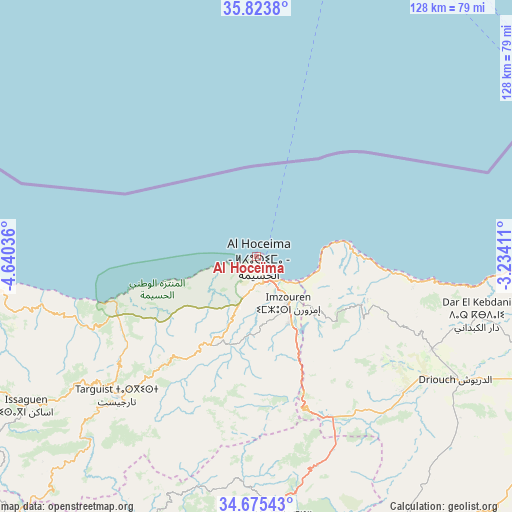
Al Hoceïma GPS coordinates[2]
35° 15' 5.94" North, 3° 56' 14.028" West
| Map corner | latitude | longitude |
|---|---|---|
| Upper-left | 35.8238°, | -4.64036° |
| Center: | 35.25165°, | -3.93723° |
| Lower-right: | 34.67543°, | -3.23411° |
| Map W x H: | 127.7×127.7 km | = 79.3×79.3mi |
| max Lat: | 35.84906° ⇑5.4% North |
| Al Hoceïma: | 35.25165° |
| min Lat: | ⇓94.6% South 22.6558° |
| min Long | Al Hoceïma | max Long |
| -15.60719° | -3.93723° | -1.22855° |
| W 88.4%⇐ | ⇒11.6% E |
Elevation
Elevation of Al Hoceïma is 74 m = 243 ft, and this is 542.8 m = 1781 ft below average elevation for this country.
| Max E: |
2637 m = 8652 ft | 82.9% |
| Avg. | 616.8 m = 2024 ft | |
| Al Hoceïma | 74 m = 243 ft | |
Min E: |
1 m = 3 ft | 17.1% |
See also: Al Hoceïma elevation on elevation.city.
Geographical zone
Al Hoceïma is located in North temperate zone (between Tropic of Cancer and the Arctic Circle). Distance of this Northern Tropic circle is 1313.7 km =816.3 mi to South.| Distance of | km | miles | from Al Hoceïma |
|---|---|---|---|
| North Pole | 6087.4 | 3782.5 | to North |
| Arctic Circle | 3481.6 | 2163.4 | to North |
| Tropic Cancer | 1313.7 | 816.3 | to South |
| Equator | 3919.6 | 2435.5 | to South |


Nearby cities:
15 places around Al Hoceïma: (largest is in red/bold)
• Ajdir
56.6 km =35.2 mi,  183°
183°
• Aknoul
66.8 km =41.5 mi,  174°
174°
• Al Aaroui
88.5 km =55 mi,  107°
107°
• Bni Bouayach
18.5 km =11.5 mi,  151°
151°
• Boudinar
30.4 km =18.9 mi, 110°
• Imzouren
14.1 km =8.8 mi, 146°
• Midar
50.5 km =31.4 mi,  133°
133°
• Nador
91.7 km =57 mi,  95°
95°
• Rouadi
21.9 km =13.6 mi,  235°
235°
• Selouane
92.6 km =57.5 mi, 102°
• Senada
32.1 km =19.9 mi,  232°
232°
• Tamorot
84.3 km =52.4 mi,  245°
245°
• Targuist
49.2 km =30.6 mi,  224°
224°
• Tirhanimîne
2.3 km =1.4 mi, 222°
• Tiztoutine
77.9 km =48.4 mi, 113°
In other languages:
- In Spanish: Villa Alhucemas, Villa Sanjurjo, Alhucemas
- In France: Al Hoceima
- In German: Al-Hoceima
Sources, notices
• [Note1] Compared only with cities in Morocco existing in our database
• [Src1] Map data: © OpenStreetMap contributors (CC-BY-SA)
• [Src2] Other city data from geonames.org with taken over terms of usage.
• [Src3] Geographical zone / Annual Mean Temperature by Robert A. Rohde @ Wikipedia
