Fandrandava geodata
Fandrandava (Upper Matsiatra) is a populated place; located in Madagascar in Indian/Antananarivo (GMT+3) time zone. With population of 9,000 people, there are 96 cities with bigger population in this country. Compared to other cities in Madagascar, 72.4% of cities are located further ↑North; 60.2% of cities are located further →East and 74% of cities have lower elevation than Fandrandava. Note1
Administrative division(s):
- Level 1: Upper Matsiatra
- Level 2: Lalangina
- Level 3: Fandrandava
- Level 4: Talata Fandrandava


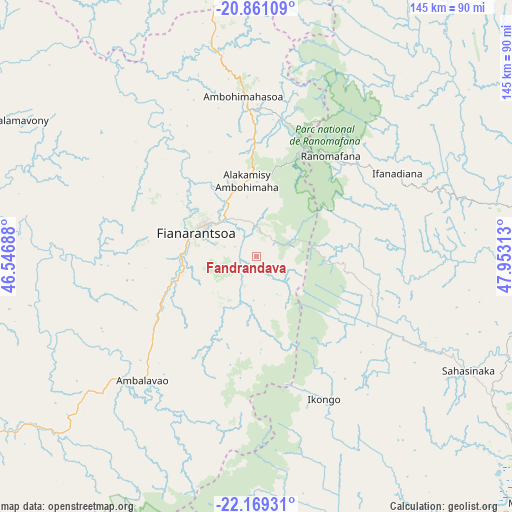
Fandrandava GPS coordinates[2]
21° 31' 0.012" South, 47° 15' 0" East
| Map corner | latitude | longitude |
|---|---|---|
| Upper-left | -20.86109°, | 46.54688° |
| Center: | -21.51667°, | 47.25° |
| Lower-right: | -22.16931°, | 47.95313° |
| Map W x H: | 145.5×145.5 km | = 90.4×90.4mi |
| max Lat: | -12.31732° ⇑72.4% North |
| Fandrandava: | -21.51667° |
| min Lat: | ⇓27.6% South -25.3° |
| min Long | Fandrandava | max Long |
| 43.65° | 47.25° | 50.27876° |
| W 39.8%⇐ | ⇒60.2% E |
Elevation
Elevation of Fandrandava is 1173 m = 3848 ft, and this is 615.6 m = 2020 ft above average elevation for this country.
| Max E: |
1763 m = 5784 ft | 26% |
| Fandrandava | 1173 m 3848 ft | |
| Avg. | 557.4 m = 1829 ft | |
Min E: |
1 m = 3 ft | 74% |
See also: Madagascar elevation on elevation.city.
Geographical zone
Fandrandava is located in South Torrid zone (between Equator and Tropic of Capricorn). Distance of this Southern Tropic circle is 213.5 km =132.7 mi to South.| Distance of | km | miles | from Fandrandava |
|---|---|---|---|
| Equator | 2392.4 | 1486.6 | to North |
| Tropic Capricorn | 213.5 | 132.7 | to South |
| Antarctic Circle | 5008.7 | 3112.3 | to South |
| South Pole | 7614.6 | 4731.5 | to South |


Nearby cities:
15 places around Fandrandava: (largest is in red/bold)
• Ambalavao
48.1 km =29.9 mi,  222°
222°
• Ambatofinandrahana
116.8 km =72.6 mi,  336°
336°
• Amboanjo
82 km =51 mi,  130°
130°
• Ambositra
109.7 km =68.2 mi,  359°
359°
• Fandriana
143.4 km =89.1 mi,  5°
5°
• Fianarantsoa
18.4 km =11.4 mi,  292°
292°
• Ifanadiana
46.4 km =28.8 mi,  58°
58°
• Ifatsy
110.9 km =68.9 mi,  152°
152°
• Ikalamavony
80.2 km =49.8 mi,  300°
300°
• Ikongo
45 km =28 mi,  155°
155°
• Manakara
105.4 km =65.5 mi, 131°
• Mananjary
117.4 km =72.9 mi,  74°
74°
• Manato
101.1 km =62.8 mi,  166°
166°
• Savana
117.4 km =72.9 mi, 145°
• Vohimanitra
50.8 km =31.6 mi,  113°
113°
Sources, notices
• [Note1] Compared only with cities in Madagascar existing in our database
• [Src1] Map data: © OpenStreetMap contributors (CC-BY-SA)
• [Src2] Other city data from geonames.org with taken over terms of usage.
• [Src3] Geographical zone / Annual Mean Temperature by Robert A. Rohde @ Wikipedia
