Manakara geodata
Manakara (Vatovavy Fitovinany) is a seat of a first-order administrative division; located in Madagascar in Indian/Antananarivo (GMT+3) time zone. With population of 35,499 people, there are 22 cities with bigger population in this country. Compared to other cities in Madagascar, 77.2% of cities are located further ↑North; 68.3% of cities are located further ←West and 96.7% of cities have higher elevation than Manakara. Note1


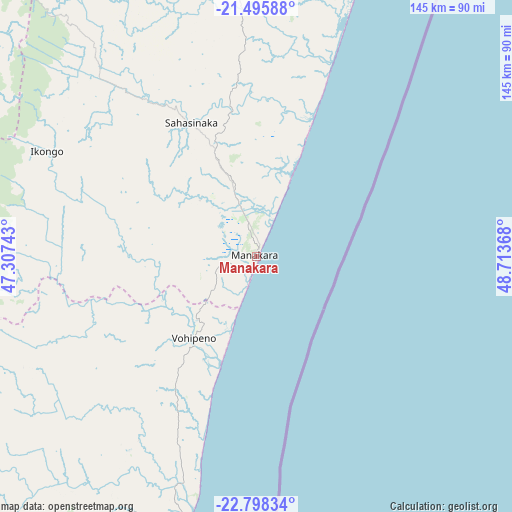
Manakara GPS coordinates[2]
22° 8' 55.032" South, 48° 0' 37.98" East
| Map corner | latitude | longitude |
|---|---|---|
| Upper-left | -21.49588°, | 47.30743° |
| Center: | -22.14862°, | 48.01055° |
| Lower-right: | -22.79834°, | 48.71368° |
| Map W x H: | 144.8×144.8 km | = 90×90mi |
| max Lat: | -12.31732° ⇑77.2% North |
| Manakara: | -22.14862° |
| min Lat: | ⇓22.8% South -25.3° |
| min Long | Manakara | max Long |
| 43.65° | 48.01055° | 50.27876° |
| W 68.3%⇐ | ⇒31.7% E |
Elevation
Elevation of Manakara is 7 m = 23 ft, and this is 550.4 m = 1806 ft below average elevation for this country.
| Max E: |
1763 m = 5784 ft | 96.7% |
| Avg. | 557.4 m = 1829 ft | |
| Manakara | 7 m = 23 ft | |
Min E: |
1 m = 3 ft | 3.3% |
See also: Madagascar elevation on elevation.city.
Geographical zone
Manakara is located in South Torrid zone (between Equator and Tropic of Capricorn). Distance of this Southern Tropic circle is 143.2 km =89 mi to South.| Distance of | km | miles | from Manakara |
|---|---|---|---|
| Equator | 2462.7 | 1530.3 | to North |
| Tropic Capricorn | 143.2 | 89 | to South |
| Antarctic Circle | 4938.5 | 3068.6 | to South |
| South Pole | 7544.4 | 4687.9 | to South |


Nearby cities:
15 places around Manakara: (largest is in red/bold)
• Ambalavao
116.5 km =72.4 mi,  287°
287°
• Amboanjo
23.4 km =14.5 mi,  314°
314°
• Anandravy
106.6 km =66.2 mi,  218°
218°
• Fandrandava
105.4 km =65.5 mi, 311°
• Farafangana
77.3 km =48 mi,  194°
194°
• Fianarantsoa
122.9 km =76.4 mi, 309°
• Ifanadiana
102.1 km =63.4 mi,  337°
337°
• Ifatsy
38.7 km =24 mi, 223°
• Ikongo
66.4 km =41.3 mi,  296°
296°
• Mananjary
107.7 km =66.9 mi,  18°
18°
• Manato
61 km =37.9 mi,  242°
242°
• Savana
28.5 km =17.7 mi,  203°
203°
• Vangaindrano
140.1 km =87.1 mi, 197°
• Vohimanitra
59.3 km =36.8 mi,  327°
327°
• Vondrozo
105.4 km =65.5 mi,  225°
225°
Sources, notices
• [Note1] Compared only with cities in Madagascar existing in our database
• [Src1] Map data: © OpenStreetMap contributors (CC-BY-SA)
• [Src2] Other city data from geonames.org with taken over terms of usage.
• [Src3] Geographical zone / Annual Mean Temperature by Robert A. Rohde @ Wikipedia
