Ifatsy geodata
Ifatsy (Vatovavy Fitovinany) is a populated place; located in Madagascar in Indian/Antananarivo (GMT+3) time zone. With population of 15,000 people, there are 84 cities with bigger population in this country. Compared to other cities in Madagascar, 80.5% of cities are located further ↑North; 56.1% of cities are located further ←West and 95.1% of cities have higher elevation than Ifatsy. Note1
Administrative division(s):
- Level 1: Vatovavy Fitovinany
- Level 2: Vohipeno
- Level 3: Ifatsy
- Level 4: Ifatsy


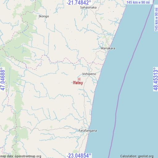
Ifatsy GPS coordinates[2]
22° 24' 0" South, 47° 45' 0" East
| Map corner | latitude | longitude |
|---|---|---|
| Upper-left | -21.74842°, | 47.04688° |
| Center: | -22.4°, | 47.75° |
| Lower-right: | -23.04854°, | 48.45313° |
| Map W x H: | 144.6×144.6 km | = 89.9×89.9mi |
| max Lat: | -12.31732° ⇑80.5% North |
| Ifatsy: | -22.4° |
| min Lat: | ⇓19.5% South -25.3° |
| min Long | Ifatsy | max Long |
| 43.65° | 47.75° | 50.27876° |
| W 56.1%⇐ | ⇒43.9% E |
Elevation
Elevation of Ifatsy is 8 m = 26 ft, and this is 549.4 m = 1802 ft below average elevation for this country.
| Max E: |
1763 m = 5784 ft | 95.1% |
| Avg. | 557.4 m = 1829 ft | |
| Ifatsy | 8 m = 26 ft | |
Min E: |
1 m = 3 ft | 4.9% |
See also: Madagascar elevation on elevation.city.
Geographical zone
Ifatsy is located in South Torrid zone (between Equator and Tropic of Capricorn). Distance of this Southern Tropic circle is 115.3 km =71.6 mi to South.| Distance of | km | miles | from Ifatsy |
|---|---|---|---|
| Equator | 2490.6 | 1547.6 | to North |
| Tropic Capricorn | 115.3 | 71.6 | to South |
| Antarctic Circle | 4910.5 | 3051.2 | to South |
| South Pole | 7516.4 | 4670.5 | to South |


Nearby cities:
15 places around Ifatsy: (largest is in red/bold)
• Ambalavao
105.1 km =65.3 mi,  306°
306°
• Amboanjo
45.7 km =28.4 mi,  13°
13°
• Anandravy
68.1 km =42.3 mi,  215°
215°
• Fandrandava
110.9 km =68.9 mi,  332°
332°
• Farafangana
47.6 km =29.6 mi,  170°
170°
• Fianarantsoa
125.7 km =78.1 mi, 326°
• Ifanadiana
122.9 km =76.4 mi,  354°
354°
• Ikongo
66.1 km =41.1 mi, 330°
• Manakara
38.7 km =24 mi,  43°
43°
• Manato
27.4 km =17 mi,  270°
270°
• Savana
15.5 km =9.6 mi,  83°
83°
• Vangaindrano
106.7 km =66.3 mi,  188°
188°
• Vohimanitra
78 km =48.5 mi,  356°
356°
• Vohipaho
130.4 km =81 mi, 191°
• Vondrozo
66.6 km =41.4 mi,  225°
225°
Sources, notices
• [Note1] Compared only with cities in Madagascar existing in our database
• [Src1] Map data: © OpenStreetMap contributors (CC-BY-SA)
• [Src2] Other city data from geonames.org with taken over terms of usage.
• [Src3] Geographical zone / Annual Mean Temperature by Robert A. Rohde @ Wikipedia
