Amboanjo geodata
Amboanjo (Vatovavy Fitovinany) is a populated place; located in Madagascar in Indian/Antananarivo (GMT+3) time zone. With population of 17,000 people, there are 72 cities with bigger population in this country. Compared to other cities in Madagascar, 76.4% of cities are located further ↑North; 63.4% of cities are located further ←West and 79.7% of cities have higher elevation than Amboanjo. Note1
Administrative division(s):
- Level 1: Vatovavy Fitovinany
- Level 2: Manakara
- Level 3: Amboanjo
- Level 4: Amboanjo


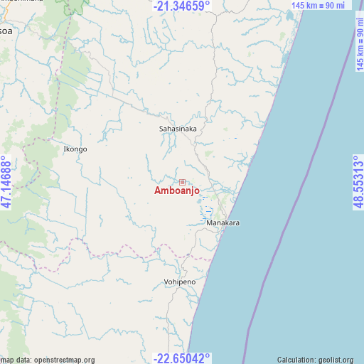
Amboanjo GPS coordinates[2]
22° 0' 0" South, 47° 51' 0" East
| Map corner | latitude | longitude |
|---|---|---|
| Upper-left | -21.34659°, | 47.14688° |
| Center: | -22°, | 47.85° |
| Lower-right: | -22.65042°, | 48.55313° |
| Map W x H: | 145×145 km | = 90.1×90.1mi |
| max Lat: | -12.31732° ⇑76.4% North |
| Amboanjo: | -22° |
| min Lat: | ⇓23.6% South -25.3° |
| min Long | Amboanjo | max Long |
| 43.65° | 47.85° | 50.27876° |
| W 63.4%⇐ | ⇒36.6% E |
Elevation
Elevation of Amboanjo is 17 m = 56 ft, and this is 540.4 m = 1773 ft below average elevation for this country.
| Max E: |
1763 m = 5784 ft | 79.7% |
| Avg. | 557.4 m = 1829 ft | |
| Amboanjo | 17 m = 56 ft | |
Min E: |
1 m = 3 ft | 20.3% |
See also: Madagascar elevation on elevation.city.
Geographical zone
Amboanjo is located in South Torrid zone (between Equator and Tropic of Capricorn). Distance of this Southern Tropic circle is 159.7 km =99.2 mi to South.| Distance of | km | miles | from Amboanjo |
|---|---|---|---|
| Equator | 2446.2 | 1520 | to North |
| Tropic Capricorn | 159.7 | 99.2 | to South |
| Antarctic Circle | 4955 | 3078.9 | to South |
| South Pole | 7560.9 | 4698.1 | to South |


Nearby cities:
15 places around Amboanjo: (largest is in red/bold)
• Ambalavao
96.4 km =59.9 mi,  281°
281°
• Anandravy
111.7 km =69.4 mi,  206°
206°
• Fandrandava
82 km =51 mi,  310°
310°
• Farafangana
91.5 km =56.9 mi,  181°
181°
• Fianarantsoa
99.7 km =62 mi, 307°
• Ifanadiana
81 km =50.3 mi,  343°
343°
• Ifatsy
45.7 km =28.4 mi,  193°
193°
• Ikongo
44.9 km =27.9 mi,  286°
286°
• Manakara
23.4 km =14.5 mi,  134°
134°
• Mananjary
99.5 km =61.8 mi,  30°
30°
• Manato
58.3 km =36.2 mi,  220°
220°
• Savana
42.9 km =26.7 mi,  173°
173°
• Vangaindrano
152.3 km =94.6 mi, 189°
• Vohimanitra
36.8 km =22.9 mi, 335°
• Vondrozo
107.9 km =67 mi, 212°
Sources, notices
• [Note1] Compared only with cities in Madagascar existing in our database
• [Src1] Map data: © OpenStreetMap contributors (CC-BY-SA)
• [Src2] Other city data from geonames.org with taken over terms of usage.
• [Src3] Geographical zone / Annual Mean Temperature by Robert A. Rohde @ Wikipedia
