Sokolo geodata
Sokolo (Ségou) is a populated place; located in Mali in Africa/Bamako (GMT+0) time zone. With population of 4,374 people, there are 35 cities with bigger population in this country. Compared to other cities in Mali, 65.6% of cities are located further ↓South; 60.7% of cities are located further →East and 68.9% of cities have higher elevation than Sokolo. Note1


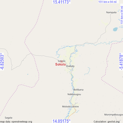
Sokolo GPS coordinates[2]
14° 43' 58.08" North, 6° 7' 18.84" West
| Map corner | latitude | longitude |
|---|---|---|
| Upper-left | 15.41173°, | -6.82503° |
| Center: | 14.7328°, | -6.1219° |
| Lower-right: | 14.05175°, | -5.41878° |
| Map W x H: | 151.2×151.2 km | = 94×94mi |
| max Lat: | 22.67443° ⇑34.4% North |
| Sokolo: | 14.7328° |
| min Lat: | ⇓65.6% South 10.55° |
| min Long | Sokolo | max Long |
| -11.44448° | -6.1219° | 3.14111° |
| W 39.3%⇐ | ⇒60.7% E |
Elevation
Elevation of Sokolo is 274 m = 899 ft, and this is 34 m = 112 ft below average elevation for this country.
| Max E: |
540 m = 1772 ft | 68.9% |
| Avg. | 308 m = 1010 ft | |
| Sokolo | 274 m = 899 ft | |
Min E: |
39 m = 128 ft | 31.1% |
See also: Mali elevation on elevation.city.
Geographical zone
Sokolo is located in North Torrid zone (between Equator and Tropic of Cancer). Distance of this Northern Tropic circle is 967.8 km =601.4 mi to North.| Distance of | km | miles | from Sokolo |
|---|---|---|---|
| North Pole | 8368.9 | 5200.2 | to North |
| Arctic Circle | 5763 | 3581 | to North |
| Tropic Cancer | 967.8 | 601.4 | to North |
| Equator | 1638.1 | 1017.9 | to South |


Nearby cities:
15 places around Sokolo: (largest is in red/bold)
• Banamba
194.4 km =120.8 mi,  227°
227°
• Barouéli
199.4 km =123.9 mi,  202°
202°
• Bla
202 km =125.5 mi,  168°
168°
• Djénné
192.4 km =119.6 mi,  118°
118°
• Ké-Macina
118.7 km =73.8 mi,  136°
136°
• Markala
114.8 km =71.3 mi,  176°
176°
• Mopti
210.4 km =130.7 mi,  97°
97°
• Nara
134 km =83.3 mi,  291°
291°
• Niono
55.2 km =34.3 mi, 165°
• San
206.8 km =128.5 mi, 140°
• Ségou
145 km =90.1 mi, 183°
• Séguéla
95 km =59 mi,  223°
223°
• Tominian
230.3 km =143.1 mi,  134°
134°
• Ténenkou
133.2 km =82.8 mi, 103°
• Youwarou
211.8 km =131.6 mi,  70°
70°
Sources, notices
• [Note1] Compared only with cities in Mali existing in our database
• [Src1] Map data: © OpenStreetMap contributors (CC-BY-SA)
• [Src2] Other city data from geonames.org with taken over terms of usage.
• [Src3] Geographical zone / Annual Mean Temperature by Robert A. Rohde @ Wikipedia
