Kayes geodata
Kayes is a seat of a first-order administrative division; located in Mali in Africa/Bamako (GMT+0) time zone. With population of 78,406 people, there are 6 cities with bigger population in this country. Compared to other cities in Mali, 59% of cities are located further ↓South; 100% of cities are located further →East and 100% of cities have higher elevation than Kayes. Note1


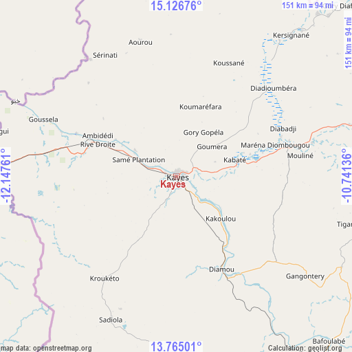
Kayes GPS coordinates[2]
14° 26' 48.948" North, 11° 26' 40.128" West
| Map corner | latitude | longitude |
|---|---|---|
| Upper-left | 15.12676°, | -12.14761° |
| Center: | 14.44693°, | -11.44448° |
| Lower-right: | 13.76501°, | -10.74136° |
| Map W x H: | 151.4×151.4 km | = 94.1×94.1mi |
| max Lat: | 22.67443° ⇑41% North |
| Kayes: | 14.44693° |
| min Lat: | ⇓59% South 10.55° |
| min Long | Kayes | max Long |
| -11.44448° | -11.44448° | 3.14111° |
| W 0%⇐ | ⇒100% E |
Elevation
Elevation of Kayes is 39 m = 128 ft, and this is 269 m = 883 ft below average elevation for this country.
| Max E: |
540 m = 1772 ft | 100% |
| Avg. | 308 m = 1010 ft | |
| Kayes | 39 m = 128 ft | |
Min E: |
39 m = 128 ft | 0% |
See also: Kayes elevation on elevation.city.
Geographical zone
Kayes is located in North Torrid zone (between Equator and Tropic of Cancer). Distance of this Northern Tropic circle is 999.6 km =621.1 mi to North.| Distance of | km | miles | from Kayes |
|---|---|---|---|
| North Pole | 8400.7 | 5220 | to North |
| Arctic Circle | 5794.8 | 3600.7 | to North |
| Tropic Cancer | 999.6 | 621.1 | to North |
| Equator | 1606.3 | 998.1 | to South |


Nearby cities:
13 places around Kayes: (largest is in red/bold)
• Bafoulabé
97.1 km =60.3 mi,  137°
137°
• Bamako
422.5 km =262.5 mi,  118°
118°
• Diré
246.1 km =152.9 mi,  167°
167°
• Diéma
242.7 km =150.8 mi,  87°
87°
• Figuira-Toma
436.1 km =271 mi,  130°
130°
• Kangaba
430.7 km =267.6 mi, 130°
• Kati
410.7 km =255.2 mi, 117°
• Kita
263.1 km =163.5 mi, 126°
• Kokofata
237.3 km =147.5 mi, 137°
• Kolokani
380.6 km =236.5 mi,  104°
104°
• Nioro
217.2 km =135 mi,  66°
66°
• Sagalo
262.5 km =163.1 mi,  162°
162°
• Yélimané
119.5 km =74.3 mi,  51°
51°
Sources, notices
• [Note1] Compared only with cities in Mali existing in our database
• [Src1] Map data: © OpenStreetMap contributors (CC-BY-SA)
• [Src2] Other city data from geonames.org with taken over terms of usage.
• [Src3] Geographical zone / Annual Mean Temperature by Robert A. Rohde @ Wikipedia
