Bafoulabé geodata
Bafoulabé (Kayes) is a seat of a second-order administrative division; located in Mali in Africa/Bamako (GMT+0) time zone. With population of 26,823 people, there are 13 cities with bigger population in this country. Compared to other cities in Mali, 54.1% of cities are located further ↑North; 96.7% of cities are located further →East and 96.7% of cities have higher elevation than Bafoulabé. Note1


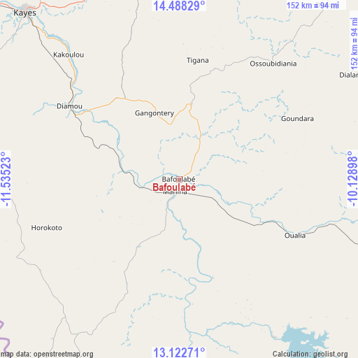
Bafoulabé GPS coordinates[2]
13° 48' 23.4" North, 10° 49' 55.56" West
| Map corner | latitude | longitude |
|---|---|---|
| Upper-left | 14.48829°, | -11.53523° |
| Center: | 13.8065°, | -10.8321° |
| Lower-right: | 13.12271°, | -10.12898° |
| Map W x H: | 151.8×151.8 km | = 94.3×94.3mi |
| max Lat: | 22.67443° ⇑54.1% North |
| Bafoulabé: | 13.8065° |
| min Lat: | ⇓45.9% South 10.55° |
| min Long | Bafoulabé | max Long |
| -11.44448° | -10.8321° | 3.14111° |
| W 3.3%⇐ | ⇒96.7% E |
Elevation
Elevation of Bafoulabé is 103 m = 338 ft, and this is 205 m = 673 ft below average elevation for this country.
| Max E: |
540 m = 1772 ft | 96.7% |
| Avg. | 308 m = 1010 ft | |
| Bafoulabé | 103 m = 338 ft | |
Min E: |
39 m = 128 ft | 3.3% |
See also: Mali elevation on elevation.city.
Geographical zone
Bafoulabé is located in North Torrid zone (between Equator and Tropic of Cancer). Distance of this Northern Tropic circle is 1070.8 km =665.4 mi to North.| Distance of | km | miles | from Bafoulabé |
|---|---|---|---|
| North Pole | 8471.9 | 5264.2 | to North |
| Arctic Circle | 5866 | 3645 | to North |
| Tropic Cancer | 1070.8 | 665.4 | to North |
| Equator | 1535.1 | 953.9 | to South |


Nearby cities:
15 places around Bafoulabé: (largest is in red/bold)
• Bamako
332.4 km =206.5 mi,  112°
112°
• Banamba
366.7 km =227.9 mi,  94°
94°
• Diré
170 km =105.6 mi,  184°
184°
• Diéma
194.7 km =121 mi,  65°
65°
• Figuira-Toma
340 km =211.3 mi,  128°
128°
• Kangaba
334.5 km =207.8 mi, 128°
• Kati
321.1 km =199.5 mi, 111°
• Kayes
97.1 km =60.3 mi,  317°
317°
• Kita
168.7 km =104.8 mi,  120°
120°
• Kokofata
140.2 km =87.1 mi,  137°
137°
• Kolokani
303.4 km =188.5 mi, 94°
• Koulikoro
369.2 km =229.4 mi, 106°
• Nioro
206.9 km =128.6 mi,  40°
40°
• Sagalo
179.2 km =111.3 mi, 175°
• Yélimané
148.5 km =92.3 mi,  10°
10°
Sources, notices
• [Note1] Compared only with cities in Mali existing in our database
• [Src1] Map data: © OpenStreetMap contributors (CC-BY-SA)
• [Src2] Other city data from geonames.org with taken over terms of usage.
• [Src3] Geographical zone / Annual Mean Temperature by Robert A. Rohde @ Wikipedia
