Yélimané geodata
Yélimané (Kayes) is a seat of a second-order administrative division; located in Mali in Africa/Bamako (GMT+0) time zone. In our database, there are 39 cities with bigger population. Compared to other cities in Mali, 68.9% of cities are located further ↓South; 93.4% of cities are located further →East and 98.4% of cities have higher elevation than Yélimané. Note1


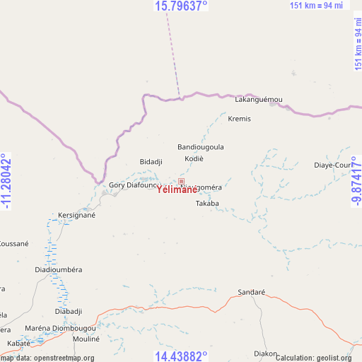
Yélimané GPS coordinates[2]
15° 7' 7.248" North, 10° 34' 38.244" West
| Map corner | latitude | longitude |
|---|---|---|
| Upper-left | 15.79637°, | -11.28042° |
| Center: | 15.11868°, | -10.57729° |
| Lower-right: | 14.43882°, | -9.87417° |
| Map W x H: | 150.9×150.9 km | = 93.8×93.8mi |
| max Lat: | 22.67443° ⇑31.1% North |
| Yélimané: | 15.11868° |
| min Lat: | ⇓68.9% South 10.55° |
| min Long | Yélimané | max Long |
| -11.44448° | -10.57729° | 3.14111° |
| W 6.6%⇐ | ⇒93.4% E |
Elevation
Elevation of Yélimané is 99 m = 325 ft, and this is 209 m = 686 ft below average elevation for this country.
| Max E: |
540 m = 1772 ft | 98.4% |
| Avg. | 308 m = 1010 ft | |
| Yélimané | 99 m = 325 ft | |
Min E: |
39 m = 128 ft | 1.6% |
See also: Mali elevation on elevation.city.
Geographical zone
Yélimané is located in North Torrid zone (between Equator and Tropic of Cancer). Distance of this Northern Tropic circle is 924.9 km =574.7 mi to North.| Distance of | km | miles | from Yélimané |
|---|---|---|---|
| North Pole | 8326 | 5173.5 | to North |
| Arctic Circle | 5720.1 | 3554.3 | to North |
| Tropic Cancer | 924.9 | 574.7 | to North |
| Equator | 1681 | 1044.5 | to South |


Nearby cities:
15 places around Yélimané: (largest is in red/bold)
• Bafoulabé
148.5 km =92.3 mi,  190°
190°
• Bamako
390.8 km =242.8 mi,  134°
134°
• Banamba
379.7 km =235.9 mi,  117°
117°
• Diré
318.1 km =197.7 mi, 187°
• Diéma
162.2 km =100.8 mi,  113°
113°
• Kangaba
424.2 km =263.6 mi,  146°
146°
• Kati
377.8 km =234.8 mi, 134°
• Kayes
119.5 km =74.3 mi,  231°
231°
• Kita
259.7 km =161.4 mi, 153°
• Kokofata
257.6 km =160.1 mi,  164°
164°
• Kolokani
323.4 km =201 mi, 122°
• Koulikoro
411 km =255.4 mi, 127°
• Nara
353.4 km =219.6 mi,  89°
89°
• Nioro
106.4 km =66.1 mi,  83°
83°
• Sagalo
324.8 km =201.8 mi,  182°
182°
Sources, notices
• [Note1] Compared only with cities in Mali existing in our database
• [Src1] Map data: © OpenStreetMap contributors (CC-BY-SA)
• [Src2] Other city data from geonames.org with taken over terms of usage.
• [Src3] Geographical zone / Annual Mean Temperature by Robert A. Rohde @ Wikipedia
