Sagalo geodata
Sagalo (Kayes) is a populated place; located in Mali in Africa/Bamako (GMT+0) time zone. With population of 15,830 people, there are 19 cities with bigger population in this country. Compared to other cities in Mali, 88.5% of cities are located further ↑North; 95.1% of cities are located further →East and 100% of cities have lower elevation than Sagalo. Note1


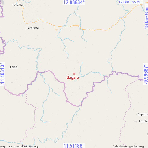
Sagalo GPS coordinates[2]
12° 12' 0" North, 10° 42' 0" West
| Map corner | latitude | longitude |
|---|---|---|
| Upper-left | 12.88634°, | -11.40313° |
| Center: | 12.2°, | -10.7° |
| Lower-right: | 11.51188°, | -9.99687° |
| Map W x H: | 152.8×152.8 km | = 94.9×94.9mi |
| max Lat: | 22.67443° ⇑88.5% North |
| Sagalo: | 12.2° |
| min Lat: | ⇓11.5% South 10.55° |
| min Long | Sagalo | max Long |
| -11.44448° | -10.7° | 3.14111° |
| W 4.9%⇐ | ⇒95.1% E |
Elevation
Elevation of Sagalo is 540 m = 1772 ft, and this is 232 m = 761 ft above average elevation for this country.
| Max E: |
540 m = 1772 ft | 0% |
| Sagalo | 540 m 1772 ft | |
| Avg. | 308 m = 1010 ft | |
Min E: |
39 m = 128 ft | 100% |
See also: Mali elevation on elevation.city.
Geographical zone
Sagalo is located in North Torrid zone (between Equator and Tropic of Cancer). Distance of this Northern Tropic circle is 1249.4 km =776.3 mi to North.| Distance of | km | miles | from Sagalo |
|---|---|---|---|
| North Pole | 8650.5 | 5375.2 | to North |
| Arctic Circle | 6044.7 | 3756 | to North |
| Tropic Cancer | 1249.4 | 776.3 | to North |
| Equator | 1356.5 | 842.9 | to South |


Nearby cities:
15 places around Sagalo: (largest is in red/bold)
• Bafoulabé
179.2 km =111.3 mi,  355°
355°
• Bamako
297.4 km =184.8 mi,  80°
80°
• Diré
30.4 km =18.9 mi,  287°
287°
• Diéma
307.1 km =190.8 mi,  32°
32°
• Figuira-Toma
255.7 km =158.9 mi,  97°
97°
• Kangaba
250 km =155.3 mi, 96°
• Kati
291.6 km =181.2 mi, 78°
• Kayes
262.5 km =163.1 mi,  342°
342°
• Kita
160.8 km =99.9 mi,  54°
54°
• Kokofata
111.4 km =69.2 mi, 46°
• Kolokani
326.8 km =203.1 mi,  62°
62°
• Koulikoro
348.7 km =216.7 mi, 77°
• Nioro
357.4 km =222.1 mi,  19°
19°
• Yanfolila
299.8 km =186.3 mi,  112°
112°
• Yélimané
324.8 km =201.8 mi,  2°
2°
Sources, notices
• [Note1] Compared only with cities in Mali existing in our database
• [Src1] Map data: © OpenStreetMap contributors (CC-BY-SA)
• [Src2] Other city data from geonames.org with taken over terms of usage.
• [Src3] Geographical zone / Annual Mean Temperature by Robert A. Rohde @ Wikipedia
