Séguéla geodata
Séguéla (Ségou) is a seat of a third-order administrative division; located in Mali in Africa/Bamako (GMT+0) time zone. In our database, there are 39 cities with bigger population. Compared to other cities in Mali, 54.1% of cities are located further ↓South; 63.9% of cities are located further →East and 57.4% of cities have higher elevation than Séguéla. Note1


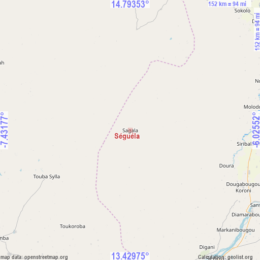
Séguéla GPS coordinates[2]
14° 6' 45.576" North, 6° 43' 43.14" West
| Map corner | latitude | longitude |
|---|---|---|
| Upper-left | 14.79353°, | -7.43177° |
| Center: | 14.11266°, | -6.72865° |
| Lower-right: | 13.42975°, | -6.02552° |
| Map W x H: | 151.6×151.6 km | = 94.2×94.2mi |
| max Lat: | 22.67443° ⇑45.9% North |
| Séguéla: | 14.11266° |
| min Lat: | ⇓54.1% South 10.55° |
| min Long | Séguéla | max Long |
| -11.44448° | -6.72865° | 3.14111° |
| W 36.1%⇐ | ⇒63.9% E |
Elevation
Elevation of Séguéla is 288 m = 945 ft, and this is 20 m = 66 ft below average elevation for this country.
| Max E: |
540 m = 1772 ft | 57.4% |
| Avg. | 308 m = 1010 ft | |
| Séguéla | 288 m = 945 ft | |
Min E: |
39 m = 128 ft | 42.6% |
See also: Mali elevation on elevation.city.
Geographical zone
Séguéla is located in North Torrid zone (between Equator and Tropic of Cancer). Distance of this Northern Tropic circle is 1036.7 km =644.2 mi to North.| Distance of | km | miles | from Séguéla |
|---|---|---|---|
| North Pole | 8437.9 | 5243.1 | to North |
| Arctic Circle | 5832 | 3623.8 | to North |
| Tropic Cancer | 1036.7 | 644.2 | to North |
| Equator | 1569.2 | 975.1 | to South |


Nearby cities:
15 places around Séguéla: (largest is in red/bold)
• Banamba
99.9 km =62.1 mi,  231°
231°
• Barouéli
115.7 km =71.9 mi,  185°
185°
• Bla
166.3 km =103.3 mi,  140°
140°
• Dioila
181.4 km =112.7 mi,  182°
182°
• Kati
210.4 km =130.7 mi,  223°
223°
• Kolokani
153.2 km =95.2 mi,  246°
246°
• Koulikoro
165.5 km =102.8 mi,  212°
212°
• Ké-Macina
148.8 km =92.5 mi,  96°
96°
• Markala
84.9 km =52.8 mi,  122°
122°
• Nara
131.8 km =81.9 mi,  333°
333°
• Niono
80.8 km =50.2 mi,  78°
78°
• Ntossoni
204.2 km =126.9 mi,  149°
149°
• Sokolo
95 km =59 mi,  43°
43°
• Ségou
93.8 km =58.3 mi, 143°
• Ténenkou
198.9 km =123.6 mi, 78°
Sources, notices
• [Note1] Compared only with cities in Mali existing in our database
• [Src1] Map data: © OpenStreetMap contributors (CC-BY-SA)
• [Src2] Other city data from geonames.org with taken over terms of usage.
• [Src3] Geographical zone / Annual Mean Temperature by Robert A. Rohde @ Wikipedia
