Kyaikto geodata
Kyaikto (Mon) is a populated place; located in Myanmar in Asia/Yangon (GMT+6.5) time zone. With population of 48,658 people, there are 48 cities with bigger population in this country. Compared to other cities in Myanmar, 56.8% of cities are located further ↑North; 68.9% of cities are located further ←West and 63.5% of cities have higher elevation than Kyaikto. Note1


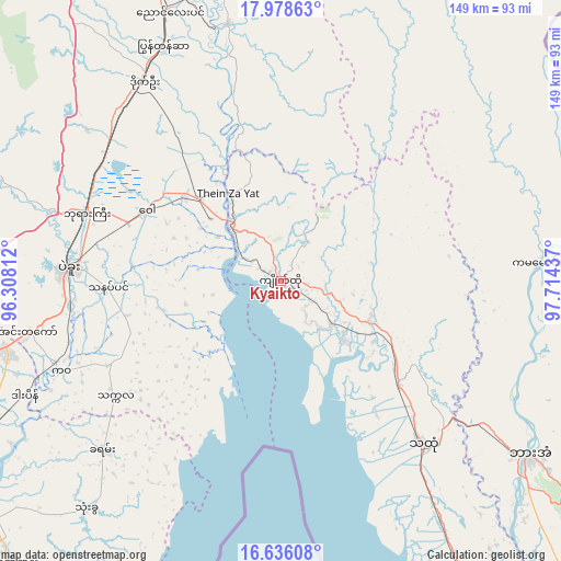
Kyaikto GPS coordinates[2]
17° 18' 30.888" North, 97° 0' 40.464" East
| Map corner | latitude | longitude |
|---|---|---|
| Upper-left | 17.97863°, | 96.30812° |
| Center: | 17.30858°, | 97.01124° |
| Lower-right: | 16.63608°, | 97.71437° |
| Map W x H: | 149.3×149.3 km | = 92.8×92.8mi |
| max Lat: | 25.38327° ⇑56.8% North |
| Kyaikto: | 17.30858° |
| min Lat: | ⇓43.2% South 9.98238° |
| min Long | Kyaikto | max Long |
| 92.89835° | 97.01124° | 99.88083° |
| W 68.9%⇐ | ⇒31.1% E |
Elevation
Elevation of Kyaikto is 23 m = 75 ft, and this is 165.9 m = 544 ft below average elevation for this country.
| Max E: |
1768 m = 5801 ft | 63.5% |
| Avg. | 188.9 m = 620 ft | |
| Kyaikto | 23 m = 75 ft | |
Min E: |
5 m = 16 ft | 36.5% |
See also: Kyaikto elevation on elevation.city.
Geographical zone
Kyaikto is located in North Torrid zone (between Equator and Tropic of Cancer). Distance of this Northern Tropic circle is 681.4 km =423.4 mi to North.| Distance of | km | miles | from Kyaikto |
|---|---|---|---|
| North Pole | 8082.5 | 5022.2 | to North |
| Arctic Circle | 5476.6 | 3403 | to North |
| Tropic Cancer | 681.4 | 423.4 | to North |
| Equator | 1924.5 | 1195.8 | to South |


Nearby cities:
15 places around Kyaikto: (largest is in red/bold)
• Bago
56.3 km =35 mi,  273°
273°
• Hpa-An
81 km =50.3 mi,  125°
125°
• Kanbe
126.5 km =78.6 mi,  238°
238°
• Kayan
65.4 km =40.6 mi,  227°
227°
• Martaban
108 km =67.1 mi,  143°
143°
• Mawlamyine
112.2 km =69.7 mi, 144°
• Mudon
139.5 km =86.7 mi,  147°
147°
• Nyaunglebin
78 km =48.5 mi,  336°
336°
• Syriam
101.2 km =62.9 mi, 233°
• Thanatpin
46.3 km =28.8 mi, 267°
• Tharyarwady
135.3 km =84.1 mi,  286°
286°
• Thaton
57.7 km =35.9 mi, 138°
• Thongwa
80 km =49.7 mi,  220°
220°
• Twante
132.9 km =82.6 mi, 239°
• Yangon
106.7 km =66.3 mi, 238°
Sources, notices
• [Note1] Compared only with cities in Myanmar existing in our database
• [Src1] Map data: © OpenStreetMap contributors (CC-BY-SA)
• [Src2] Other city data from geonames.org with taken over terms of usage.
• [Src3] Geographical zone / Annual Mean Temperature by Robert A. Rohde @ Wikipedia
