Thaton geodata
Thaton (Mon) is a populated place; located in Myanmar in Asia/Yangon (GMT+6.5) time zone. With population of 123,727 people, there are 18 cities with bigger population in this country. Compared to other cities in Myanmar, 60.8% of cities are located further ↑North; 74.3% of cities are located further ←West and 60.8% of cities have higher elevation than Thaton. Note1


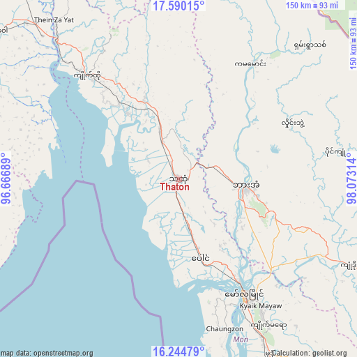
Thaton GPS coordinates[2]
16° 55' 7.212" North, 97° 22' 12.036" East
| Map corner | latitude | longitude |
|---|---|---|
| Upper-left | 17.59015°, | 96.66689° |
| Center: | 16.91867°, | 97.37001° |
| Lower-right: | 16.24479°, | 98.07314° |
| Map W x H: | 149.6×149.6 km | = 93×93mi |
| max Lat: | 25.38327° ⇑60.8% North |
| Thaton: | 16.91867° |
| min Lat: | ⇓39.2% South 9.98238° |
| min Long | Thaton | max Long |
| 92.89835° | 97.37001° | 99.88083° |
| W 74.3%⇐ | ⇒25.7% E |
Elevation
Elevation of Thaton is 24 m = 79 ft, and this is 164.9 m = 541 ft below average elevation for this country.
| Max E: |
1768 m = 5801 ft | 60.8% |
| Avg. | 188.9 m = 620 ft | |
| Thaton | 24 m = 79 ft | |
Min E: |
5 m = 16 ft | 39.2% |
See also: Thaton elevation on elevation.city.
Geographical zone
Thaton is located in North Torrid zone (between Equator and Tropic of Cancer). Distance of this Northern Tropic circle is 724.7 km =450.3 mi to North.| Distance of | km | miles | from Thaton |
|---|---|---|---|
| North Pole | 8125.9 | 5049.2 | to North |
| Arctic Circle | 5520 | 3430 | to North |
| Tropic Cancer | 724.7 | 450.3 | to North |
| Equator | 1881.2 | 1168.9 | to South |


Nearby cities:
15 places around Thaton: (largest is in red/bold)
• Bago
105.2 km =65.4 mi,  296°
296°
• Dellok
113.8 km =70.7 mi,  149°
149°
• Hpa-An
28.4 km =17.6 mi,  96°
96°
• Kayan
86.1 km =53.5 mi,  269°
269°
• Kyaikkami
95.9 km =59.6 mi,  167°
167°
• Kyaikto
57.7 km =35.9 mi,  318°
318°
• Martaban
50.7 km =31.5 mi, 148°
• Mawlamyine
55 km =34.2 mi, 149°
• Mudon
82.8 km =51.4 mi, 152°
• Pulei
109.8 km =68.2 mi, 150°
• Syriam
120.9 km =75.1 mi,  262°
262°
• Tagondaing
110.6 km =68.7 mi, 148°
• Tamoowoug
114.2 km =71 mi, 149°
• Thanatpin
94.1 km =58.5 mi, 296°
• Thongwa
91.6 km =56.9 mi, 258°
Sources, notices
• [Note1] Compared only with cities in Myanmar existing in our database
• [Src1] Map data: © OpenStreetMap contributors (CC-BY-SA)
• [Src2] Other city data from geonames.org with taken over terms of usage.
• [Src3] Geographical zone / Annual Mean Temperature by Robert A. Rohde @ Wikipedia
