Mawlamyine geodata
Mawlamyine (Mon) is a seat of a first-order administrative division; located in Myanmar in Asia/Yangon (GMT+6.5) time zone. With population of 438,861 people, there are 3 cities with bigger population in this country. Compared to other cities in Myanmar, 78.4% of cities are located further ↑North; 79.7% of cities are located further ←West and 58.1% of cities have lower elevation than Mawlamyine. Note1


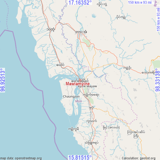
Mawlamyine GPS coordinates[2]
16° 29' 25.836" North, 97° 37' 41.7" East
| Map corner | latitude | longitude |
|---|---|---|
| Upper-left | 17.16352°, | 96.92513° |
| Center: | 16.49051°, | 97.62825° |
| Lower-right: | 15.81515°, | 98.33138° |
| Map W x H: | 149.9×149.9 km | = 93.1×93.1mi |
| max Lat: | 25.38327° ⇑78.4% North |
| Mawlamyine: | 16.49051° |
| min Lat: | ⇓21.6% South 9.98238° |
| min Long | Mawlamyine | max Long |
| 92.89835° | 97.62825° | 99.88083° |
| W 79.7%⇐ | ⇒20.3% E |
Elevation
Elevation of Mawlamyine is 52 m = 171 ft, and this is 136.9 m = 449 ft below average elevation for this country.
| Max E: |
1768 m = 5801 ft | 41.9% |
| Avg. | 188.9 m = 620 ft | |
| Mawlamyine | 52 m = 171 ft | |
Min E: |
5 m = 16 ft | 58.1% |
See also: Mawlamyine elevation on elevation.city.
Geographical zone
Mawlamyine is located in North Torrid zone (between Equator and Tropic of Cancer). Distance of this Northern Tropic circle is 772.3 km =479.9 mi to North.| Distance of | km | miles | from Mawlamyine |
|---|---|---|---|
| North Pole | 8173.5 | 5078.8 | to North |
| Arctic Circle | 5567.6 | 3459.5 | to North |
| Tropic Cancer | 772.3 | 479.9 | to North |
| Equator | 1833.6 | 1139.3 | to South |


Nearby cities:
15 places around Mawlamyine: (largest is in red/bold)
• Dellok
58.8 km =36.5 mi,  148°
148°
• Hpa-An
44.4 km =27.6 mi,  0°
0°
• Klonhtoug
104.5 km =64.9 mi,  124°
124°
• Kyaikkami
46.5 km =28.9 mi,  188°
188°
• Kyaikto
112.2 km =69.7 mi,  324°
324°
• Kyain Seikgyi Township
99.8 km =62 mi,  138°
138°
• Martaban
4.4 km =2.7 mi,  342°
342°
• Mikenaungea
103.8 km =64.5 mi, 124°
• Mudon
28 km =17.4 mi,  158°
158°
• Myawadi
96.4 km =59.9 mi,  76°
76°
• Pulei
54.8 km =34.1 mi, 150°
• Tagondaing
55.7 km =34.6 mi, 147°
• Tamoowoug
59.2 km =36.8 mi, 148°
• Thaton
55 km =34.2 mi,  329°
329°
• Thongwa
121.3 km =75.4 mi,  284°
284°
Sources, notices
• [Note1] Compared only with cities in Myanmar existing in our database
• [Src1] Map data: © OpenStreetMap contributors (CC-BY-SA)
• [Src2] Other city data from geonames.org with taken over terms of usage.
• [Src3] Geographical zone / Annual Mean Temperature by Robert A. Rohde @ Wikipedia
