Myawadi geodata
Myawadi (Kayin) is a populated place; located in Myanmar in Asia/Yangon (GMT+6.5) time zone. With population of 45,000 people, there are 53 cities with bigger population in this country. Compared to other cities in Myanmar, 74.3% of cities are located further ↑North; 95.9% of cities are located further ←West and 85.1% of cities have lower elevation than Myawadi. Note1


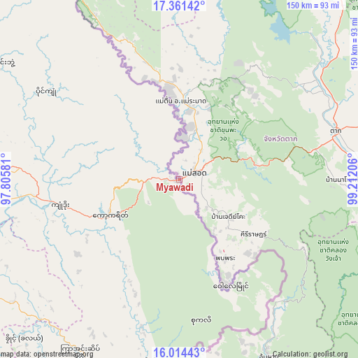
Myawadi GPS coordinates[2]
16° 41' 20.796" North, 98° 30' 32.148" East
| Map corner | latitude | longitude |
|---|---|---|
| Upper-left | 17.36142°, | 97.80581° |
| Center: | 16.68911°, | 98.50893° |
| Lower-right: | 16.01443°, | 99.21206° |
| Map W x H: | 149.8×149.8 km | = 93.1×93.1mi |
| max Lat: | 25.38327° ⇑74.3% North |
| Myawadi: | 16.68911° |
| min Lat: | ⇓25.7% South 9.98238° |
| min Long | Myawadi | max Long |
| 92.89835° | 98.50893° | 99.88083° |
| W 95.9%⇐ | ⇒4.1% E |
Elevation
Elevation of Myawadi is 206 m = 676 ft, and this is 17.1 m = 56 ft above average elevation for this country.
| Max E: |
1768 m = 5801 ft | 14.9% |
| Myawadi | 206 m 676 ft | |
| Avg. | 188.9 m = 620 ft | |
Min E: |
5 m = 16 ft | 85.1% |
See also: Myawadi elevation on elevation.city.
Geographical zone
Myawadi is located in North Torrid zone (between Equator and Tropic of Cancer). Distance of this Northern Tropic circle is 750.3 km =466.2 mi to North.| Distance of | km | miles | from Myawadi |
|---|---|---|---|
| North Pole | 8151.4 | 5065 | to North |
| Arctic Circle | 5545.5 | 3445.8 | to North |
| Tropic Cancer | 750.3 | 466.2 | to North |
| Equator | 1855.7 | 1153.1 | to South |


Nearby cities:
15 places around Myawadi: (largest is in red/bold)
• Dellok
95.8 km =59.5 mi,  221°
221°
• Hpa-An
95.7 km =59.5 mi,  283°
283°
• Kayan
208.8 km =129.7 mi, 276°
• Klonhtoug
82.1 km =51 mi,  185°
185°
• Kyaikkami
121.6 km =75.6 mi,  235°
235°
• Kyaikto
173.5 km =107.8 mi,  293°
293°
• Kyain Seikgyi Township
100.1 km =62.2 mi,  195°
195°
• Martaban
96.8 km =60.1 mi,  259°
259°
• Mawlamyine
96.4 km =59.9 mi, 256°
• Mikenaungea
81.7 km =50.8 mi, 186°
• Mudon
96.5 km =60 mi, 240°
• Pulei
96.5 km =60 mi, 223°
• Tagondaing
94.3 km =58.6 mi, 222°
• Tamoowoug
96.5 km =60 mi, 221°
• Thaton
123.9 km =77 mi, 281°
Sources, notices
• [Note1] Compared only with cities in Myanmar existing in our database
• [Src1] Map data: © OpenStreetMap contributors (CC-BY-SA)
• [Src2] Other city data from geonames.org with taken over terms of usage.
• [Src3] Geographical zone / Annual Mean Temperature by Robert A. Rohde @ Wikipedia
