Thongwa geodata
Thongwa (Rangoon) is a populated place; located in Myanmar in Asia/Yangon (GMT+6.5) time zone. With population of 52,496 people, there are 42 cities with bigger population in this country. Compared to other cities in Myanmar, 68.9% of cities are located further ↑North; 60.8% of cities are located further ←West and 94.6% of cities have higher elevation than Thongwa. Note1


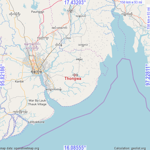
Thongwa GPS coordinates[2]
16° 45' 35.928" North, 96° 31' 29.928" East
| Map corner | latitude | longitude |
|---|---|---|
| Upper-left | 17.43203°, | 95.82186° |
| Center: | 16.75998°, | 96.52498° |
| Lower-right: | 16.08555°, | 97.22811° |
| Map W x H: | 149.7×149.7 km | = 93×93mi |
| max Lat: | 25.38327° ⇑68.9% North |
| Thongwa: | 16.75998° |
| min Lat: | ⇓31.1% South 9.98238° |
| min Long | Thongwa | max Long |
| 92.89835° | 96.52498° | 99.88083° |
| W 60.8%⇐ | ⇒39.2% E |
Elevation
Elevation of Thongwa is 10 m = 33 ft, and this is 178.9 m = 587 ft below average elevation for this country.
| Max E: |
1768 m = 5801 ft | 94.6% |
| Avg. | 188.9 m = 620 ft | |
| Thongwa | 10 m = 33 ft | |
Min E: |
5 m = 16 ft | 5.4% |
See also: Thongwa elevation on elevation.city.
Geographical zone
Thongwa is located in North Torrid zone (between Equator and Tropic of Cancer). Distance of this Northern Tropic circle is 742.4 km =461.3 mi to North.| Distance of | km | miles | from Thongwa |
|---|---|---|---|
| North Pole | 8143.5 | 5060.1 | to North |
| Arctic Circle | 5537.6 | 3440.9 | to North |
| Tropic Cancer | 742.4 | 461.3 | to North |
| Equator | 1863.5 | 1157.9 | to South |


Nearby cities:
15 places around Thongwa: (largest is in red/bold)
• Bago
64.1 km =39.8 mi,  355°
355°
• Hpa-An
119 km =73.9 mi,  83°
83°
• Kanbe
56 km =34.8 mi,  263°
263°
• Kayan
16.9 km =10.5 mi,  12°
12°
• Kyaiklat
92.3 km =57.4 mi,  247°
247°
• Kyaikto
80 km =49.7 mi,  40°
40°
• Martaban
119 km =73.9 mi,  102°
102°
• Maubin
92.7 km =57.6 mi,  268°
268°
• Nyaungdon
99.4 km =61.8 mi,  288°
288°
• Pyapon
104.5 km =64.9 mi,  239°
239°
• Syriam
29.8 km =18.5 mi, 271°
• Thanatpin
59.3 km =36.8 mi, 5°
• Thaton
91.6 km =56.9 mi, 78°
• Twante
63.7 km =39.6 mi, 265°
• Yangon
39.6 km =24.6 mi,  277°
277°
Sources, notices
• [Note1] Compared only with cities in Myanmar existing in our database
• [Src1] Map data: © OpenStreetMap contributors (CC-BY-SA)
• [Src2] Other city data from geonames.org with taken over terms of usage.
• [Src3] Geographical zone / Annual Mean Temperature by Robert A. Rohde @ Wikipedia
