Buyant geodata
Buyant (Dzabkhan) is a seat of a second-order administrative division; located in Mongolia in Asia/Hovd (GMT+7) time zone. In our database, there are 33 cities with bigger population. Compared to other cities in Mongolia, 58% of cities are located further ↑North; 74.8% of cities are located further →East and 95.1% of cities have lower elevation than Buyant. Note1


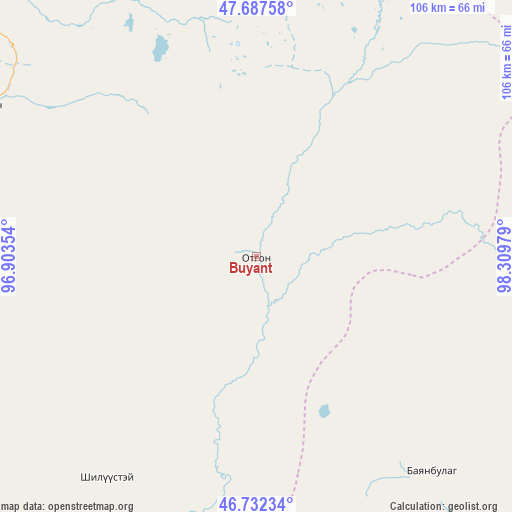
Buyant GPS coordinates[2]
47° 12' 43.596" North, 97° 36' 23.976" East
| Map corner | latitude | longitude |
|---|---|---|
| Upper-left | 47.68758°, | 96.90354° |
| Center: | 47.21211°, | 97.60666° |
| Lower-right: | 46.73234°, | 98.30979° |
| Map W x H: | 106.2×106.2 km | = 66×66mi |
| max Lat: | 51.50725° ⇑58% North |
| Buyant: | 47.21211° |
| min Lat: | ⇓42% South 42.84199° |
| min Long | Buyant | max Long |
| 89.14358° | 97.60666° | 118.51014° |
| W 25.2%⇐ | ⇒74.8% E |
Elevation
Elevation of Buyant is 2155 m = 7070 ft, and this is 738.5 m = 2423 ft above average elevation for this country.
| Max E: |
2800 m = 9186 ft | 4.9% |
| Buyant | 2155 m 7070 ft | |
| Avg. | 1416.5 m = 4647 ft | |
Min E: |
619 m = 2031 ft | 95.1% |
See also: Mongolia elevation on elevation.city.
Geographical zone
Buyant is located in North temperate zone (between Tropic of Cancer and the Arctic Circle). Distance of this North polar circle is 2151.7 km =1337 mi to North.| Distance of | km | miles | from Buyant |
|---|---|---|---|
| North Pole | 4757.6 | 2956.2 | to North |
| Arctic Circle | 2151.7 | 1337 | to North |
| Tropic Cancer | 2643.6 | 1642.7 | to South |
| Equator | 5249.5 | 3261.9 | to South |


Nearby cities:
15 places around Buyant: (largest is in red/bold)
• Aldar
93.6 km =58.2 mi,  300°
300°
• Balgatay
49 km =30.4 mi,  224°
224°
• Bayanbulag
57.8 km =35.9 mi,  140°
140°
• Buyanbat
129.9 km =80.7 mi,  258°
258°
• Chandmanĭ
137.9 km =85.7 mi,  312°
312°
• Delgermörön
103.2 km =64.1 mi,  149°
149°
• Dzag
121.9 km =75.7 mi,  104°
104°
• Dzuunmod
113.4 km =70.5 mi,  351°
351°
• Höviyn Am
72.9 km =45.3 mi,  88°
88°
• Shiree
68.3 km =42.4 mi, 297°
• Taygan
97.2 km =60.4 mi,  190°
190°
• Tsagaan-Olom
99 km =61.5 mi,  235°
235°
• Tsagaanchuluut
71.6 km =44.5 mi, 261°
• Tsahir
134.2 km =83.4 mi,  44°
44°
• Uliastay
82.1 km =51 mi,  315°
315°
Sources, notices
• [Note1] Compared only with cities in Mongolia existing in our database
• [Src1] Map data: © OpenStreetMap contributors (CC-BY-SA)
• [Src2] Other city data from geonames.org with taken over terms of usage.
• [Src3] Geographical zone / Annual Mean Temperature by Robert A. Rohde @ Wikipedia
