Jargalant geodata
Jargalant (Bayanhongor) is a seat of a second-order administrative division; located in Mongolia in Asia/Ulaanbaatar (GMT+8) time zone. In our database, there are 33 cities with bigger population. Compared to other cities in Mongolia, 59.8% of cities are located further ↑North; 66.9% of cities are located further →East and 96.6% of cities have lower elevation than Jargalant. Note1


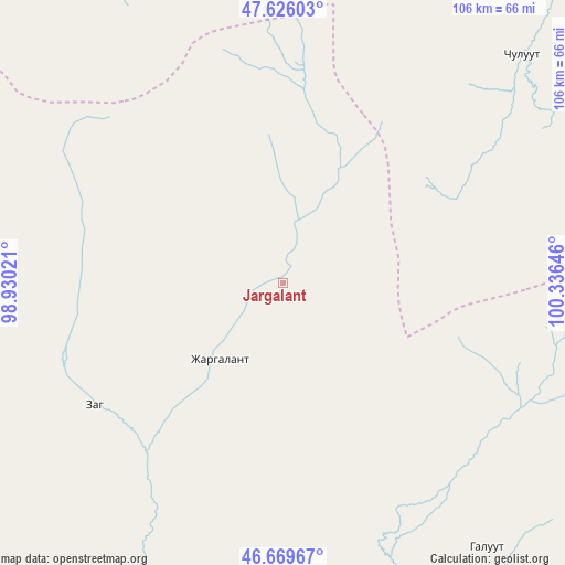
Jargalant GPS coordinates[2]
47° 9' 0" North, 99° 37' 59.988" East
| Map corner | latitude | longitude |
|---|---|---|
| Upper-left | 47.62603°, | 98.93021° |
| Center: | 47.15°, | 99.63333° |
| Lower-right: | 46.66967°, | 100.33646° |
| Map W x H: | 106.3×106.3 km | = 66.1×66.1mi |
| max Lat: | 51.50725° ⇑59.8% North |
| Jargalant: | 47.15° |
| min Lat: | ⇓40.2% South 42.84199° |
| min Long | Jargalant | max Long |
| 89.14358° | 99.63333° | 118.51014° |
| W 33.1%⇐ | ⇒66.9% E |
Elevation
Elevation of Jargalant is 2215 m = 7267 ft, and this is 798.5 m = 2620 ft above average elevation for this country.
| Max E: |
2800 m = 9186 ft | 3.4% |
| Jargalant | 2215 m 7267 ft | |
| Avg. | 1416.5 m = 4647 ft | |
Min E: |
619 m = 2031 ft | 96.6% |
See also: Mongolia elevation on elevation.city.
Geographical zone
Jargalant is located in North temperate zone (between Tropic of Cancer and the Arctic Circle). Distance of this North polar circle is 2158.6 km =1341.3 mi to North.| Distance of | km | miles | from Jargalant |
|---|---|---|---|
| North Pole | 4764.5 | 2960.5 | to North |
| Arctic Circle | 2158.6 | 1341.3 | to North |
| Tropic Cancer | 2636.7 | 1638.4 | to South |
| Equator | 5242.6 | 3257.6 | to South |


Nearby cities:
15 places around Jargalant: (largest is in red/bold)
• Bayanbulag
123 km =76.4 mi,  252°
252°
• Bayanhongor
60.6 km =37.7 mi,  142°
142°
• Bayanhoshuu
63.1 km =39.2 mi, 142°
• Bulagiyn Denj
113.5 km =70.5 mi,  80°
80°
• Dzaanhoshuu
101.3 km =62.9 mi,  67°
67°
• Dzadgay
104.5 km =64.9 mi,  181°
181°
• Dzag
42.2 km =26.2 mi,  236°
236°
• Erdenetsogt
121.7 km =75.6 mi,  131°
131°
• Horgo
113.8 km =70.7 mi,  9°
9°
• Hunt
80.7 km =50.1 mi,  351°
351°
• Höhbürd
114.4 km =71.1 mi,  147°
147°
• Höviyn Am
80.7 km =50.1 mi,  276°
276°
• Jargalant
61.2 km =38 mi,  45°
45°
• Teel
119.4 km =74.2 mi,  33°
33°
• Tsahir
118.8 km =73.8 mi,  330°
330°
Sources, notices
• [Note1] Compared only with cities in Mongolia existing in our database
• [Src1] Map data: © OpenStreetMap contributors (CC-BY-SA)
• [Src2] Other city data from geonames.org with taken over terms of usage.
• [Src3] Geographical zone / Annual Mean Temperature by Robert A. Rohde @ Wikipedia
