Horgo geodata
Horgo (Arhangay) is a seat of a second-order administrative division; located in Mongolia in Asia/Ulaanbaatar (GMT+8) time zone. In our database, there are 33 cities with bigger population. Compared to other cities in Mongolia, 60.7% of cities are located further ↓South; 66% of cities are located further →East and 91.4% of cities have lower elevation than Horgo. Note1


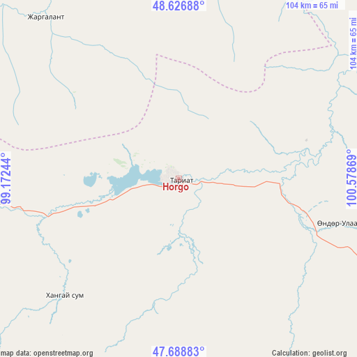
Horgo GPS coordinates[2]
48° 9' 36" North, 99° 52' 32.016" East
| Map corner | latitude | longitude |
|---|---|---|
| Upper-left | 48.62688°, | 99.17244° |
| Center: | 48.16°, | 99.87556° |
| Lower-right: | 47.68883°, | 100.57869° |
| Map W x H: | 104.3×104.3 km | = 64.8×64.8mi |
| max Lat: | 51.50725° ⇑39.3% North |
| Horgo: | 48.16° |
| min Lat: | ⇓60.7% South 42.84199° |
| min Long | Horgo | max Long |
| 89.14358° | 99.87556° | 118.51014° |
| W 34%⇐ | ⇒66% E |
Elevation
Elevation of Horgo is 2052 m = 6732 ft, and this is 635.5 m = 2085 ft above average elevation for this country.
| Max E: |
2800 m = 9186 ft | 8.6% |
| Horgo | 2052 m 6732 ft | |
| Avg. | 1416.5 m = 4647 ft | |
Min E: |
619 m = 2031 ft | 91.4% |
See also: Mongolia elevation on elevation.city.
Geographical zone
Horgo is located in North temperate zone (between Tropic of Cancer and the Arctic Circle). Distance of this North polar circle is 2046.3 km =1271.5 mi to North.| Distance of | km | miles | from Horgo |
|---|---|---|---|
| North Pole | 4652.2 | 2890.7 | to North |
| Arctic Circle | 2046.3 | 1271.5 | to North |
| Tropic Cancer | 2749 | 1708.1 | to South |
| Equator | 5354.9 | 3327.4 | to South |


Nearby cities:
15 places around Horgo: (largest is in red/bold)
• Bayan-Uhaa
101.3 km =62.9 mi,  307°
307°
• Bayantsagaan
91.1 km =56.6 mi,  45°
45°
• Bulagiyn Denj
131.7 km =81.8 mi,  135°
135°
• Dzaanhoshuu
105.3 km =65.4 mi,  134°
134°
• Erdenet
91.2 km =56.7 mi,  344°
344°
• Hujirt
128.6 km =79.9 mi, 51°
• Hunt
44.6 km =27.7 mi,  222°
222°
• Ider
68.1 km =42.3 mi,  359°
359°
• Jargalant
74.2 km =46.1 mi,  159°
159°
• Jargalant
113.8 km =70.7 mi,  189°
189°
• Jargalant
129.4 km =80.4 mi,  12°
12°
• Orgil
61.3 km =38.1 mi,  320°
320°
• Teel
48.7 km =30.3 mi,  105°
105°
• Tsahir
76.5 km =47.5 mi,  263°
263°
• Öldziyt
118.1 km =73.4 mi,  69°
69°
Sources, notices
• [Note1] Compared only with cities in Mongolia existing in our database
• [Src1] Map data: © OpenStreetMap contributors (CC-BY-SA)
• [Src2] Other city data from geonames.org with taken over terms of usage.
• [Src3] Geographical zone / Annual Mean Temperature by Robert A. Rohde @ Wikipedia
