Erdenet geodata
Erdenet (Hövsgöl) is a seat of a second-order administrative division; located in Mongolia in Asia/Ulaanbaatar (GMT+8) time zone. In our database, there are 33 cities with bigger population. Compared to other cities in Mongolia, 75.5% of cities are located further ↓South; 67.8% of cities are located further →East and 74.5% of cities have lower elevation than Erdenet. Note1


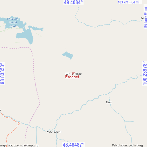
Erdenet GPS coordinates[2]
48° 56' 55.572" North, 99° 32' 11.94" East
| Map corner | latitude | longitude |
|---|---|---|
| Upper-left | 49.4084°, | 98.83353° |
| Center: | 48.94877°, | 99.53665° |
| Lower-right: | 48.48487°, | 100.23978° |
| Map W x H: | 102.7×102.7 km | = 63.8×63.8mi |
| max Lat: | 51.50725° ⇑24.5% North |
| Erdenet: | 48.94877° |
| min Lat: | ⇓75.5% South 42.84199° |
| min Long | Erdenet | max Long |
| 89.14358° | 99.53665° | 118.51014° |
| W 32.2%⇐ | ⇒67.8% E |
Elevation
Elevation of Erdenet is 1690 m = 5545 ft, and this is 273.5 m = 897 ft above average elevation for this country.
| Max E: |
2800 m = 9186 ft | 25.5% |
| Erdenet | 1690 m 5545 ft | |
| Avg. | 1416.5 m = 4647 ft | |
Min E: |
619 m = 2031 ft | 74.5% |
See also: Mongolia elevation on elevation.city.
Geographical zone
Erdenet is located in North temperate zone (between Tropic of Cancer and the Arctic Circle). Distance of this North polar circle is 1958.6 km =1217 mi to North.| Distance of | km | miles | from Erdenet |
|---|---|---|---|
| North Pole | 4564.5 | 2836.2 | to North |
| Arctic Circle | 1958.6 | 1217 | to North |
| Tropic Cancer | 2836.7 | 1762.6 | to South |
| Equator | 5442.6 | 3381.9 | to South |


Nearby cities:
15 places around Erdenet: (largest is in red/bold)
• Bayan
54.1 km =33.6 mi,  4°
4°
• Bayan-Uhaa
60.2 km =37.4 mi,  244°
244°
• Bayantsagaan
92.7 km =57.6 mi,  105°
105°
• Horgo
91.2 km =56.7 mi,  164°
164°
• Hunt
120.4 km =74.8 mi,  182°
182°
• Ider
31.5 km =19.6 mi,  128°
128°
• Jargalant
65.1 km =40.5 mi,  53°
53°
• Mandal
106 km =65.9 mi,  355°
355°
• Murun-kuren
88.7 km =55.1 mi,  30°
30°
• Orgil
42.4 km =26.3 mi,  198°
198°
• Sharga
108.6 km =67.5 mi,  330°
330°
• Teel
123.3 km =76.6 mi,  144°
144°
• Tosontsengel
94.1 km =58.5 mi,  256°
256°
• Tsahir
109 km =67.7 mi,  207°
207°
• Tsengel
114.5 km =71.1 mi,  59°
59°
Sources, notices
• [Note1] Compared only with cities in Mongolia existing in our database
• [Src1] Map data: © OpenStreetMap contributors (CC-BY-SA)
• [Src2] Other city data from geonames.org with taken over terms of usage.
• [Src3] Geographical zone / Annual Mean Temperature by Robert A. Rohde @ Wikipedia
