Tosontsengel geodata
Tosontsengel (Dzabkhan) is a seat of a second-order administrative division; located in Mongolia in Asia/Hovd (GMT+7) time zone. With population of 9,526 people, there are 24 cities with bigger population in this country. Compared to other cities in Mongolia, 72.4% of cities are located further ↓South; 73% of cities are located further →East and 76.7% of cities have lower elevation than Tosontsengel. Note1


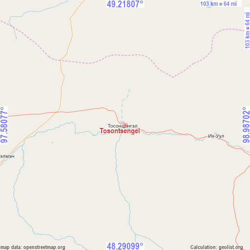
Tosontsengel GPS coordinates[2]
48° 45' 24.012" North, 98° 17' 2.004" East
| Map corner | latitude | longitude |
|---|---|---|
| Upper-left | 49.21807°, | 97.58077° |
| Center: | 48.75667°, | 98.28389° |
| Lower-right: | 48.29099°, | 98.98702° |
| Map W x H: | 103.1×103.1 km | = 64.1×64.1mi |
| max Lat: | 51.50725° ⇑27.6% North |
| Tosontsengel: | 48.75667° |
| min Lat: | ⇓72.4% South 42.84199° |
| min Long | Tosontsengel | max Long |
| 89.14358° | 98.28389° | 118.51014° |
| W 27%⇐ | ⇒73% E |
Elevation
Elevation of Tosontsengel is 1717 m = 5633 ft, and this is 300.5 m = 986 ft above average elevation for this country.
| Max E: |
2800 m = 9186 ft | 23.3% |
| Tosontsengel | 1717 m 5633 ft | |
| Avg. | 1416.5 m = 4647 ft | |
Min E: |
619 m = 2031 ft | 76.7% |
See also: Mongolia elevation on elevation.city.
Geographical zone
Tosontsengel is located in North temperate zone (between Tropic of Cancer and the Arctic Circle). Distance of this North polar circle is 1979.9 km =1230.3 mi to North.| Distance of | km | miles | from Tosontsengel |
|---|---|---|---|
| North Pole | 4585.8 | 2849.5 | to North |
| Arctic Circle | 1979.9 | 1230.3 | to North |
| Tropic Cancer | 2815.3 | 1749.3 | to South |
| Equator | 5421.2 | 3368.6 | to South |


Nearby cities:
15 places around Tosontsengel: (largest is in red/bold)
• Asgat
136.7 km =84.9 mi,  307°
307°
• Bayan
121.8 km =75.7 mi,  51°
51°
• Bayan-Uhaa
37.5 km =23.3 mi,  96°
96°
• Dzuunmod
89.7 km =55.7 mi,  228°
228°
• Erdenet
94.1 km =58.5 mi,  76°
76°
• Halban
94.5 km =58.7 mi,  335°
335°
• Horgo
134.8 km =83.8 mi,  119°
119°
• Hunt
132.1 km =82.1 mi,  138°
138°
• Hödrögö
97.6 km =60.6 mi,  277°
277°
• Ider
116.5 km =72.4 mi,  89°
89°
• Orgil
80.6 km =50.1 mi, 103°
• Oygon
129.8 km =80.7 mi, 281°
• Sharga
121.9 km =75.7 mi,  17°
17°
• Telmin Suma
50.4 km =31.3 mi,  255°
255°
• Tsahir
86.1 km =53.5 mi,  150°
150°
Sources, notices
• [Note1] Compared only with cities in Mongolia existing in our database
• [Src1] Map data: © OpenStreetMap contributors (CC-BY-SA)
• [Src2] Other city data from geonames.org with taken over terms of usage.
• [Src3] Geographical zone / Annual Mean Temperature by Robert A. Rohde @ Wikipedia
