Aldar geodata
Aldar (Dzabkhan) is a seat of a second-order administrative division; located in Mongolia in Asia/Hovd (GMT+7) time zone. In our database, there are 33 cities with bigger population. Compared to other cities in Mongolia, 50.6% of cities are located further ↑North; 78.5% of cities are located further →East and 72.7% of cities have lower elevation than Aldar. Note1


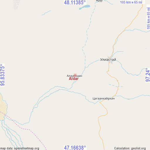
Aldar GPS coordinates[2]
47° 38' 32.136" North, 96° 32' 12.732" East
| Map corner | latitude | longitude |
|---|---|---|
| Upper-left | 48.11385°, | 95.83375° |
| Center: | 47.64226°, | 96.53687° |
| Lower-right: | 47.16638°, | 97.24° |
| Map W x H: | 105.3×105.3 km | = 65.4×65.4mi |
| max Lat: | 51.50725° ⇑50.6% North |
| Aldar: | 47.64226° |
| min Lat: | ⇓49.4% South 42.84199° |
| min Long | Aldar | max Long |
| 89.14358° | 96.53687° | 118.51014° |
| W 21.5%⇐ | ⇒78.5% E |
Elevation
Elevation of Aldar is 1649 m = 5410 ft, and this is 232.5 m = 763 ft above average elevation for this country.
| Max E: |
2800 m = 9186 ft | 27.3% |
| Aldar | 1649 m 5410 ft | |
| Avg. | 1416.5 m = 4647 ft | |
Min E: |
619 m = 2031 ft | 72.7% |
See also: Mongolia elevation on elevation.city.
Geographical zone
Aldar is located in North temperate zone (between Tropic of Cancer and the Arctic Circle). Distance of this North polar circle is 2103.9 km =1307.3 mi to North.| Distance of | km | miles | from Aldar |
|---|---|---|---|
| North Pole | 4709.7 | 2926.5 | to North |
| Arctic Circle | 2103.9 | 1307.3 | to North |
| Tropic Cancer | 2691.4 | 1672.4 | to South |
| Equator | 5297.3 | 3291.6 | to South |


Nearby cities:
15 places around Aldar: (largest is in red/bold)
• Altan
80.8 km =50.2 mi,  310°
310°
• Balgatay
94.6 km =58.8 mi,  150°
150°
• Bayan
124 km =77.1 mi,  234°
234°
• Buga
115.1 km =71.5 mi,  270°
270°
• Buyanbat
87 km =54.1 mi,  211°
211°
• Buyant
93.6 km =58.2 mi,  120°
120°
• Chandmanĭ
50.1 km =31.1 mi,  334°
334°
• Dzuunmod
89.5 km =55.6 mi,  44°
44°
• Holboo
133.4 km =82.9 mi,  322°
322°
• Nuga
129.6 km =80.5 mi, 305°
• Shiree
25.7 km =16 mi,  128°
128°
• Tegsh
129.6 km =80.5 mi,  342°
342°
• Tsagaan-Olom
103.3 km =64.2 mi,  180°
180°
• Tsagaanchuluut
59.8 km =37.2 mi,  170°
170°
• Uliastay
25.5 km =15.8 mi,  64°
64°
Sources, notices
• [Note1] Compared only with cities in Mongolia existing in our database
• [Src1] Map data: © OpenStreetMap contributors (CC-BY-SA)
• [Src2] Other city data from geonames.org with taken over terms of usage.
• [Src3] Geographical zone / Annual Mean Temperature by Robert A. Rohde @ Wikipedia
