Hithadhoo geodata
Hithadhoo (Laamu) is a populated place; located in Maldives in Indian/Maldives (GMT+5) time zone. With population of 683 people, there are 26 cities with bigger population in this country. Compared to other cities in Maldives, 82.1% of cities are located further ↑North; 64.3% of cities are located further ←West and 100% of cities have lower elevation than Hithadhoo. Note1


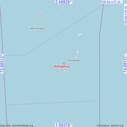
Hithadhoo GPS coordinates[2]
1° 47' 47.976" North, 73° 23' 17.664" East
| Map corner | latitude | longitude |
|---|---|---|
| Upper-left | 2.49929°, | 72.68512° |
| Center: | 1.79666°, | 73.38824° |
| Lower-right: | 1.09376°, | 74.09137° |
| Map W x H: | 156.3×156.3 km | = 97.1×97.1mi |
| max Lat: | 6.88744° ⇑82.1% North |
| Hithadhoo: | 1.79666° |
| min Lat: | ⇓17.9% South -0.6° |
| min Long | Hithadhoo | max Long |
| 72.89437° | 73.38824° | 73.56667° |
| W 64.3%⇐ | ⇒35.7% E |
Elevation
Elevation of Hithadhoo is 12 m = 39 ft, and this is 4.7 m = 15 ft above average elevation for this country.
| Max E: |
12 m = 39 ft | 0% |
| Hithadhoo | 12 m 39 ft | |
| Avg. | 7.3 m = 24 ft | |
Min E: |
-1 m = -3 ft | 100% |
See also: Maldives elevation on elevation.city.
Geographical zone
Hithadhoo is located in North Torrid zone (between Equator and Tropic of Cancer). Distance of Equator is 199.8 km =124.1 mi to South.| Distance of | km | miles | from Hithadhoo |
|---|---|---|---|
| North Pole | 9807.3 | 6094 | to North |
| Arctic Circle | 7201.4 | 4474.7 | to North |
| Tropic Cancer | 2406.1 | 1495.1 | to North |
| Equator | 199.8 | 124.1 | to South |


Nearby cities:
15 places around Hithadhoo: (largest is in red/bold)
• Buruni
90.3 km =56.1 mi,  339°
339°
• Diyamigili
60.7 km =37.7 mi,  354°
354°
• Felidhoo
187.1 km =116.3 mi,  5°
5°
• Fonadhoo
13.3 km =8.3 mi,  72°
72°
• Fuvahmulah
233 km =144.8 mi,  179°
179°
• Guraidhoo
59.2 km =36.8 mi, 352°
• Guraidhoo
234.1 km =145.5 mi,  2°
2°
• Kudahuvadhoo
111.6 km =69.3 mi,  330°
330°
• Madifushi
62.3 km =38.7 mi,  356°
356°
• Mahibadhoo
222.9 km =138.5 mi, 347°
• Muli
126.1 km =78.4 mi, 9°
• Thinadhoo
147.3 km =91.5 mi,  197°
197°
• Veymandoo
54.3 km =33.7 mi,  323°
323°
• Viligili
115.5 km =71.8 mi, 177°
• Vilufushi
79 km =49.1 mi, 353°
Sources, notices
• [Note1] Compared only with cities in Maldives existing in our database
• [Src1] Map data: © OpenStreetMap contributors (CC-BY-SA)
• [Src2] Other city data from geonames.org with taken over terms of usage.
• [Src3] Geographical zone / Annual Mean Temperature by Robert A. Rohde @ Wikipedia
