Ugoofaaru geodata
Ugoofaaru (Raa Atoll) is a seat of a first-order administrative division; located in Maldives in Indian/Maldives (GMT+5) time zone. With population of 1,575 people, there are 19 cities with bigger population in this country. Compared to other cities in Maldives, 85.7% of cities are located further ↓South; 89.3% of cities are located further →East and 60.7% of cities have lower elevation than Ugoofaaru. Note1


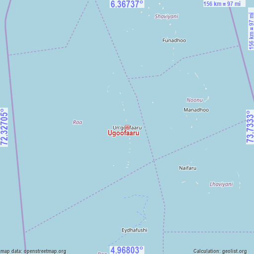
Ugoofaaru GPS coordinates[2]
5° 40' 5.232" North, 73° 1' 48.612" East
| Map corner | latitude | longitude |
|---|---|---|
| Upper-left | 6.36737°, | 72.32705° |
| Center: | 5.66812°, | 73.03017° |
| Lower-right: | 4.96803°, | 73.7333° |
| Map W x H: | 155.6×155.6 km | = 96.7×96.7mi |
| max Lat: | 6.88744° ⇑14.3% North |
| Ugoofaaru: | 5.66812° |
| min Lat: | ⇓85.7% South -0.6° |
| min Long | Ugoofaaru | max Long |
| 72.89437° | 73.03017° | 73.56667° |
| W 10.7%⇐ | ⇒89.3% E |
Elevation
Elevation of Ugoofaaru is 9 m = 30 ft, and this is 1.7 m = 6 ft above average elevation for this country.
| Max E: |
12 m = 39 ft | 39.3% |
| Ugoofaaru | 9 m 30 ft | |
| Avg. | 7.3 m = 24 ft | |
Min E: |
-1 m = -3 ft | 60.7% |
See also: Maldives elevation on elevation.city.
Geographical zone
Ugoofaaru is located in North Torrid zone (between Equator and Tropic of Cancer). Distance of Equator is 630.2 km =391.6 mi to South.| Distance of | km | miles | from Ugoofaaru |
|---|---|---|---|
| North Pole | 9376.8 | 5826.5 | to North |
| Arctic Circle | 6770.9 | 4207.2 | to North |
| Tropic Cancer | 1975.7 | 1227.6 | to North |
| Equator | 630.2 | 391.6 | to South |


Nearby cities:
15 places around Ugoofaaru: (largest is in red/bold)
• Dhidhdhoo
135.9 km =84.4 mi,  3°
3°
• Eydhafushi
63 km =39.1 mi,  175°
175°
• Felidhoo
250.8 km =155.8 mi,  166°
166°
• Funadhoo
60.9 km =37.8 mi,  28°
28°
• Guraidhoo
202.4 km =125.8 mi, 166°
• Hulhumale
171.5 km =106.6 mi,  160°
160°
• Kudahuvadhoo
333.6 km =207.3 mi, 182°
• Kulhudhuffushi
106.2 km =66 mi, 2°
• Maafushi
198.6 km =123.4 mi, 165°
• Mahibadhoo
212.6 km =132.1 mi, 181°
• Male
174.3 km =108.3 mi, 162°
• Manadhoo
43.8 km =27.2 mi,  75°
75°
• Muli
311.7 km =193.7 mi, 168°
• Naifaru
44.7 km =27.8 mi,  123°
123°
• Open Stage
62.7 km =39 mi, 175°
Sources, notices
• [Note1] Compared only with cities in Maldives existing in our database
• [Src1] Map data: © OpenStreetMap contributors (CC-BY-SA)
• [Src2] Other city data from geonames.org with taken over terms of usage.
• [Src3] Geographical zone / Annual Mean Temperature by Robert A. Rohde @ Wikipedia
