Funadhoo geodata
Funadhoo (Shaviyani Atholhu) is a seat of a first-order administrative division; located in Maldives in Indian/Maldives (GMT+5) time zone. With population of 2,900 people, there are 10 cities with bigger population in this country. Compared to other cities in Maldives, 92.9% of cities are located further ↓South; 57.1% of cities are located further →East and 60.7% of cities have lower elevation than Funadhoo. Note1


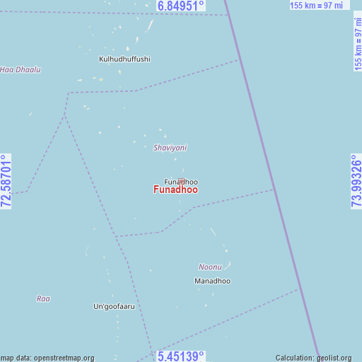
Funadhoo GPS coordinates[2]
6° 9' 3.276" North, 73° 17' 24.468" East
| Map corner | latitude | longitude |
|---|---|---|
| Upper-left | 6.84951°, | 72.58701° |
| Center: | 6.15091°, | 73.29013° |
| Lower-right: | 5.45139°, | 73.99326° |
| Map W x H: | 155.5×155.5 km | = 96.6×96.6mi |
| max Lat: | 6.88744° ⇑7.1% North |
| Funadhoo: | 6.15091° |
| min Lat: | ⇓92.9% South -0.6° |
| min Long | Funadhoo | max Long |
| 72.89437° | 73.29013° | 73.56667° |
| W 42.9%⇐ | ⇒57.1% E |
Elevation
Elevation of Funadhoo is 9 m = 30 ft, and this is 1.7 m = 6 ft above average elevation for this country.
| Max E: |
12 m = 39 ft | 39.3% |
| Funadhoo | 9 m 30 ft | |
| Avg. | 7.3 m = 24 ft | |
Min E: |
-1 m = -3 ft | 60.7% |
See also: Maldives elevation on elevation.city.
Geographical zone
Funadhoo is located in North Torrid zone (between Equator and Tropic of Cancer). Distance of Equator is 683.9 km =425 mi to South.| Distance of | km | miles | from Funadhoo |
|---|---|---|---|
| North Pole | 9323.1 | 5793.1 | to North |
| Arctic Circle | 6717.3 | 4173.9 | to North |
| Tropic Cancer | 1922 | 1194.3 | to North |
| Equator | 683.9 | 425 | to South |


Nearby cities:
15 places around Funadhoo: (largest is in red/bold)
• Dhidhdhoo
84.2 km =52.3 mi,  346°
346°
• Eydhafushi
119 km =73.9 mi,  191°
191°
• Felidhoo
299.2 km =185.9 mi,  174°
174°
• Guraidhoo
251 km =156 mi,  175°
175°
• Hulhumale
217.4 km =135.1 mi, 172°
• Kudahuvadhoo
389.4 km =242 mi, 186°
• Kulhudhuffushi
57.8 km =35.9 mi,  335°
335°
• Maafushi
246.6 km =153.2 mi, 174°
• Mahibadhoo
268.5 km =166.8 mi, 187°
• Male
221 km =137.3 mi, 173°
• Manadhoo
44.8 km =27.8 mi,  162°
162°
• Muli
360.9 km =224.3 mi, 175°
• Naifaru
79 km =49.1 mi, 173°
• Open Stage
118.8 km =73.8 mi, 191°
• Ugoofaaru
60.9 km =37.8 mi,  208°
208°
Sources, notices
• [Note1] Compared only with cities in Maldives existing in our database
• [Src1] Map data: © OpenStreetMap contributors (CC-BY-SA)
• [Src2] Other city data from geonames.org with taken over terms of usage.
• [Src3] Geographical zone / Annual Mean Temperature by Robert A. Rohde @ Wikipedia
