Dhidhdhoo geodata
Dhidhdhoo (Haa Alifu Atholhu) is a seat of a first-order administrative division; located in Maldives in Indian/Maldives (GMT+5) time zone. With population of 3,039 people, there are 7 cities with bigger population in this country. Compared to other cities in Maldives, 100% of cities are located further ↓South; 64.3% of cities are located further →East and 57.1% of cities have higher elevation than Dhidhdhoo. Note1


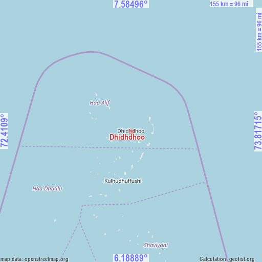
Dhidhdhoo GPS coordinates[2]
6° 53' 14.784" North, 73° 6' 50.472" East
| Map corner | latitude | longitude |
|---|---|---|
| Upper-left | 7.58496°, | 72.4109° |
| Center: | 6.88744°, | 73.11402° |
| Lower-right: | 6.18889°, | 73.81715° |
| Map W x H: | 155.2×155.2 km | = 96.4×96.4mi |
| max Lat: | 6.88744° ⇑0% North |
| Dhidhdhoo: | 6.88744° |
| min Lat: | ⇓100% South -0.6° |
| min Long | Dhidhdhoo | max Long |
| 72.89437° | 73.11402° | 73.56667° |
| W 35.7%⇐ | ⇒64.3% E |
Elevation
Elevation of Dhidhdhoo is 8 m = 26 ft, and this is 0.7 m = 2 ft above average elevation for this country.
| Max E: |
12 m = 39 ft | 57.1% |
| Dhidhdhoo | 8 m 26 ft | |
| Avg. | 7.3 m = 24 ft | |
Min E: |
-1 m = -3 ft | 42.9% |
See also: Maldives elevation on elevation.city.
Geographical zone
Dhidhdhoo is located in North Torrid zone (between Equator and Tropic of Cancer). Distance of Equator is 765.8 km =475.8 mi to South.| Distance of | km | miles | from Dhidhdhoo |
|---|---|---|---|
| North Pole | 9241.3 | 5742.3 | to North |
| Arctic Circle | 6635.4 | 4123 | to North |
| Tropic Cancer | 1840.1 | 1143.4 | to North |
| Equator | 765.8 | 475.8 | to South |


Nearby cities:
14 places around Dhidhdhoo: (largest is in red/bold)
• Eydhafushi
198.4 km =123.3 mi,  181°
181°
• Felidhoo
382.8 km =237.9 mi,  172°
172°
• Funadhoo
84.2 km =52.3 mi, 166°
• Guraidhoo
334.4 km =207.8 mi, 173°
• Hulhumale
301.2 km =187.2 mi, 170°
• Kulhudhuffushi
29.9 km =18.6 mi,  189°
189°
• Maafushi
330.1 km =205.1 mi, 172°
• Mahibadhoo
348.4 km =216.5 mi, 182°
• Male
304.7 km =189.3 mi, 171°
• Manadhoo
128.9 km =80.1 mi, 165°
• Muli
444.3 km =276.1 mi, 173°
• Naifaru
162.8 km =101.2 mi, 170°
• Open Stage
198.2 km =123.2 mi, 181°
• Ugoofaaru
135.9 km =84.4 mi, 183°
Sources, notices
• [Note1] Compared only with cities in Maldives existing in our database
• [Src1] Map data: © OpenStreetMap contributors (CC-BY-SA)
• [Src2] Other city data from geonames.org with taken over terms of usage.
• [Src3] Geographical zone / Annual Mean Temperature by Robert A. Rohde @ Wikipedia
