Manadhoo geodata
Manadhoo (Noonu Atoll) is a seat of a first-order administrative division; located in Maldives in Indian/Maldives (GMT+5) time zone. With population of 1,580 people, there are 18 cities with bigger population in this country. Compared to other cities in Maldives, 89.3% of cities are located further ↓South; 67.9% of cities are located further ←West and 57.1% of cities have higher elevation than Manadhoo. Note1


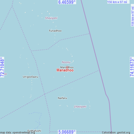
Manadhoo GPS coordinates[2]
5° 46' 0.732" North, 73° 24' 48.96" East
| Map corner | latitude | longitude |
|---|---|---|
| Upper-left | 6.46599°, | 72.71048° |
| Center: | 5.76687°, | 73.4136° |
| Lower-right: | 5.06689°, | 74.11673° |
| Map W x H: | 155.6×155.6 km | = 96.7×96.7mi |
| max Lat: | 6.88744° ⇑10.7% North |
| Manadhoo: | 5.76687° |
| min Lat: | ⇓89.3% South -0.6° |
| min Long | Manadhoo | max Long |
| 72.89437° | 73.4136° | 73.56667° |
| W 67.9%⇐ | ⇒32.1% E |
Elevation
Elevation of Manadhoo is 8 m = 26 ft, and this is 0.7 m = 2 ft above average elevation for this country.
| Max E: |
12 m = 39 ft | 57.1% |
| Manadhoo | 8 m 26 ft | |
| Avg. | 7.3 m = 24 ft | |
Min E: |
-1 m = -3 ft | 42.9% |
See also: Maldives elevation on elevation.city.
Geographical zone
Manadhoo is located in North Torrid zone (between Equator and Tropic of Cancer). Distance of Equator is 641.2 km =398.4 mi to South.| Distance of | km | miles | from Manadhoo |
|---|---|---|---|
| North Pole | 9365.8 | 5819.6 | to North |
| Arctic Circle | 6760 | 4200.5 | to North |
| Tropic Cancer | 1964.7 | 1220.8 | to North |
| Equator | 641.2 | 398.4 | to South |


Nearby cities:
15 places around Manadhoo: (largest is in red/bold)
• Dhidhdhoo
128.9 km =80.1 mi,  345°
345°
• Eydhafushi
83 km =51.6 mi,  207°
207°
• Felidhoo
255.6 km =158.8 mi,  176°
176°
• Funadhoo
44.8 km =27.8 mi,  342°
342°
• Guraidhoo
207.6 km =129 mi, 178°
• Hulhumale
173.5 km =107.8 mi, 175°
• Kudahuvadhoo
349 km =216.9 mi,  189°
189°
• Kulhudhuffushi
102.4 km =63.6 mi, 338°
• Maafushi
203.1 km =126.2 mi, 177°
• Mahibadhoo
228.8 km =142.2 mi, 192°
• Male
177.3 km =110.2 mi, 176°
• Muli
317.4 km =197.2 mi, 176°
• Naifaru
36.2 km =22.5 mi, 188°
• Open Stage
82.8 km =51.4 mi, 207°
• Ugoofaaru
43.8 km =27.2 mi,  255°
255°
Sources, notices
• [Note1] Compared only with cities in Maldives existing in our database
• [Src1] Map data: © OpenStreetMap contributors (CC-BY-SA)
• [Src2] Other city data from geonames.org with taken over terms of usage.
• [Src3] Geographical zone / Annual Mean Temperature by Robert A. Rohde @ Wikipedia
