Kulhudhuffushi geodata
Kulhudhuffushi (Haa Dhaalu Atholhu) is a seat of a first-order administrative division; located in Maldives in Indian/Maldives (GMT+5) time zone. With population of 9,500 people, there are 3 cities with bigger population in this country. Compared to other cities in Maldives, 96.4% of cities are located further ↓South; 85.7% of cities are located further →East and 85.7% of cities have higher elevation than Kulhudhuffushi. Note1


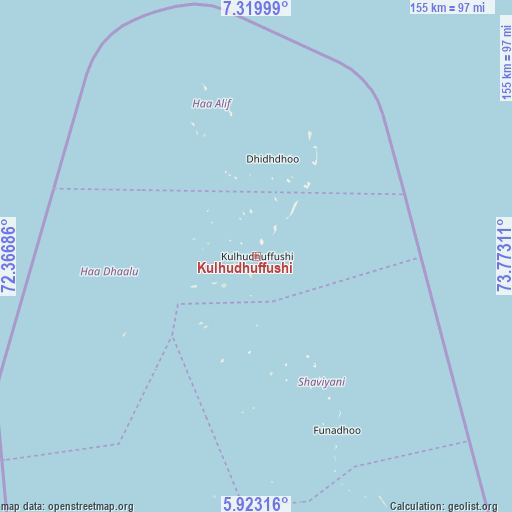
Kulhudhuffushi GPS coordinates[2]
6° 37' 19.452" North, 73° 4' 11.928" East
| Map corner | latitude | longitude |
|---|---|---|
| Upper-left | 7.31999°, | 72.36686° |
| Center: | 6.62207°, | 73.06998° |
| Lower-right: | 5.92316°, | 73.77311° |
| Map W x H: | 155.3×155.3 km | = 96.5×96.5mi |
| max Lat: | 6.88744° ⇑3.6% North |
| Kulhudhuffushi: | 6.62207° |
| min Lat: | ⇓96.4% South -0.6° |
| min Long | Kulhudhuffushi | max Long |
| 72.89437° | 73.06998° | 73.56667° |
| W 14.3%⇐ | ⇒85.7% E |
Elevation
Elevation of Kulhudhuffushi is 6 m = 20 ft, and this is 1.3 m = 4 ft below average elevation for this country.
| Max E: |
12 m = 39 ft | 85.7% |
| Avg. | 7.3 m = 24 ft | |
| Kulhudhuffushi | 6 m = 20 ft | |
Min E: |
-1 m = -3 ft | 14.3% |
See also: Maldives elevation on elevation.city.
Geographical zone
Kulhudhuffushi is located in North Torrid zone (between Equator and Tropic of Cancer). Distance of Equator is 736.3 km =457.5 mi to South.| Distance of | km | miles | from Kulhudhuffushi |
|---|---|---|---|
| North Pole | 9270.8 | 5760.6 | to North |
| Arctic Circle | 6664.9 | 4141.4 | to North |
| Tropic Cancer | 1869.6 | 1161.7 | to North |
| Equator | 736.3 | 457.5 | to South |


Nearby cities:
15 places around Kulhudhuffushi: (largest is in red/bold)
• Dhidhdhoo
29.9 km =18.6 mi,  9°
9°
• Eydhafushi
168.9 km =104.9 mi,  179°
179°
• Felidhoo
354.2 km =220.1 mi,  171°
171°
• Funadhoo
57.8 km =35.9 mi,  155°
155°
• Guraidhoo
305.8 km =190 mi, 171°
• Hulhumale
273 km =169.6 mi, 169°
• Kudahuvadhoo
439.8 km =273.3 mi, 182°
• Maafushi
301.6 km =187.4 mi, 171°
• Mahibadhoo
318.7 km =198 mi, 182°
• Male
276.4 km =171.7 mi, 169°
• Manadhoo
102.4 km =63.6 mi, 158°
• Muli
415.7 km =258.3 mi, 172°
• Naifaru
135 km =83.9 mi, 165°
• Open Stage
168.6 km =104.8 mi, 179°
• Ugoofaaru
106.2 km =66 mi, 182°
Sources, notices
• [Note1] Compared only with cities in Maldives existing in our database
• [Src1] Map data: © OpenStreetMap contributors (CC-BY-SA)
• [Src2] Other city data from geonames.org with taken over terms of usage.
• [Src3] Geographical zone / Annual Mean Temperature by Robert A. Rohde @ Wikipedia
