Vega de Alatorre geodata
Vega de Alatorre (Veracruz) is a seat of a second-order administrative division; located in Mexico in America/Mexico_City (GMT-6) time zone. With population of 7,653 people, there are 1214 cities with bigger population in this country. Compared to other cities in Mexico, 57.6% of cities are located further ↓South; 78.8% of cities are located further ←West and 89% of cities have higher elevation than Vega de Alatorre. Note1


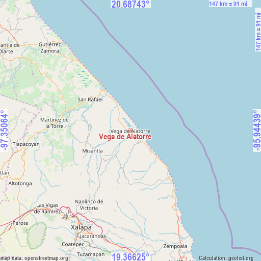
Vega de Alatorre GPS coordinates[2]
20° 1' 41.628" North, 96° 38' 51.036" West
| Map corner | latitude | longitude |
|---|---|---|
| Upper-left | 20.68743°, | -97.35064° |
| Center: | 20.02823°, | -96.64751° |
| Lower-right: | 19.36625°, | -95.94439° |
| Map W x H: | 146.9×146.9 km | = 91.3×91.3mi |
| max Lat: | 32.7° ⇑42.4% North |
| Vega de Alatorre: | 20.02823° |
| min Lat: | ⇓57.6% South 14.53588° |
| min Long | Vega de Alatorr | max Long |
| -117.105° | -96.64751° | -86.73105° |
| W 78.8%⇐ | ⇒21.2% E |
Elevation
Elevation of Vega de Alatorre is 27 m = 89 ft, and this is 1226.7 m = 4025 ft below average elevation for this country.
| Max E: |
3497 m = 11473 ft | 89% |
| Avg. | 1253.7 m = 4113 ft | |
| Vega de Alatorre | 27 m = 89 ft | |
Min E: |
-1 m = -3 ft | 11% |
See also: Mexico elevation on elevation.city.
Geographical zone
Vega de Alatorre is located in North Torrid zone (between Equator and Tropic of Cancer). Distance of this Northern Tropic circle is 379 km =235.5 mi to North.| Distance of | km | miles | from Vega de Alatorre |
|---|---|---|---|
| North Pole | 7780.1 | 4834.3 | to North |
| Arctic Circle | 5174.2 | 3215.1 | to North |
| Tropic Cancer | 379 | 235.5 | to North |
| Equator | 2226.9 | 1383.7 | to South |


Nearby cities:
15 places around Vega de Alatorre: (largest is in red/bold)
• Arroyo Frío
14.2 km =8.8 mi,  239°
239°
• Barra de Palmas
17 km =10.6 mi,  330°
330°
• Colipa
14.3 km =8.9 mi,  215°
215°
• Cuautitlán del Parral
22.3 km =13.9 mi,  203°
203°
• Dos Arroyos
19 km =11.8 mi, 199°
• El Chaparral
17.5 km =10.9 mi,  181°
181°
• El Ciervo
13.3 km =8.3 mi,  269°
269°
• Juchique de Ferrer
21.5 km =13.4 mi,  193°
193°
• Las Higueras
2.8 km =1.7 mi,  70°
70°
• Loma del Cojolite
19.1 km =11.9 mi,  252°
252°
• Plan de la Vega
17.8 km =11.1 mi, 243°
• Santa Ana
21.2 km =13.2 mi,  136°
136°
• Venustiano Carranza
21.8 km =13.5 mi,  231°
231°
• Villa Emilio Carranza
7.5 km =4.7 mi,  149°
149°
• Yecuatla
22.6 km =14 mi, 217°
Sources, notices
• [Note1] Compared only with cities in Mexico existing in our database
• [Src1] Map data: © OpenStreetMap contributors (CC-BY-SA)
• [Src2] Other city data from geonames.org with taken over terms of usage.
• [Src3] Geographical zone / Annual Mean Temperature by Robert A. Rohde @ Wikipedia
