Huitzilan geodata
Huitzilan (Puebla) is a seat of a second-order administrative division; located in Mexico in America/Mexico_City (GMT-6) time zone. With population of 3,567 people, there are 2562 cities with bigger population in this country. Compared to other cities in Mexico, 56.4% of cities are located further ↓South; 67.3% of cities are located further ←West and 61.3% of cities have higher elevation than Huitzilan. Note1


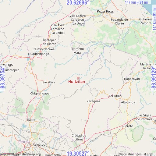
Huitzilan GPS coordinates[2]
19° 58' 3" North, 97° 41' 39.876" West
| Map corner | latitude | longitude |
|---|---|---|
| Upper-left | 20.62696°, | -98.39754° |
| Center: | 19.9675°, | -97.69441° |
| Lower-right: | 19.30527°, | -96.99129° |
| Map W x H: | 147×147 km | = 91.3×91.3mi |
| max Lat: | 32.7° ⇑43.6% North |
| Huitzilan: | 19.9675° |
| min Lat: | ⇓56.4% South 14.53588° |
| min Long | Huitzilan | max Long |
| -117.105° | -97.69441° | -86.73105° |
| W 67.3%⇐ | ⇒32.7% E |
Elevation
Elevation of Huitzilan is 922 m = 3025 ft, and this is 331.7 m = 1088 ft below average elevation for this country.
| Max E: |
3497 m = 11473 ft | 61.3% |
| Avg. | 1253.7 m = 4113 ft | |
| Huitzilan | 922 m = 3025 ft | |
Min E: |
-1 m = -3 ft | 38.7% |
See also: Mexico elevation on elevation.city.
Geographical zone
Huitzilan is located in North Torrid zone (between Equator and Tropic of Cancer). Distance of this Northern Tropic circle is 385.7 km =239.7 mi to North.| Distance of | km | miles | from Huitzilan |
|---|---|---|---|
| North Pole | 7786.9 | 4838.6 | to North |
| Arctic Circle | 5181 | 3219.3 | to North |
| Tropic Cancer | 385.7 | 239.7 | to North |
| Equator | 2220.2 | 1379.6 | to South |


Nearby cities:
15 places around Huitzilan: (largest is in red/bold)
• Cuarta Sección
0.7 km =0.4 mi,  18°
18°
• Huapalegcan
3.2 km =2 mi,  120°
120°
• Hueytlalpan
6.6 km =4.1 mi,  357°
357°
• Ignacio Allende (Concepción)
7.9 km =4.9 mi,  52°
52°
• Nanacatlán
4.5 km =2.8 mi,  25°
25°
• Pahuatla
4 km =2.5 mi,  139°
139°
• Primera Sección
0.6 km =0.4 mi,  161°
161°
• San Antonio Taltzintán
7.6 km =4.7 mi,  210°
210°
• San Martín
7.1 km =4.4 mi, 50°
• San Miguel del Progreso
3.8 km =2.4 mi, 49°
• Tapayula
7.7 km =4.8 mi,  317°
317°
• Tuxtla
5.5 km =3.4 mi, 48°
• Zapotitlán
4.3 km =2.7 mi,  332°
332°
• Zongozotla
3.7 km =2.3 mi,  290°
290°
• Zoyotla
4.4 km =2.7 mi,  179°
179°
Sources, notices
• [Note1] Compared only with cities in Mexico existing in our database
• [Src1] Map data: © OpenStreetMap contributors (CC-BY-SA)
• [Src2] Other city data from geonames.org with taken over terms of usage.
• [Src3] Geographical zone / Annual Mean Temperature by Robert A. Rohde @ Wikipedia
