Nanacatlán geodata
Nanacatlán (Puebla) is a populated place; located in Mexico in America/Mexico_City (GMT-6) time zone. With population of 1,183 people, there are 7346 cities with bigger population in this country. Compared to other cities in Mexico, 57% of cities are located further ↓South; 67.6% of cities are located further ←West and 61.2% of cities have higher elevation than Nanacatlán. Note1


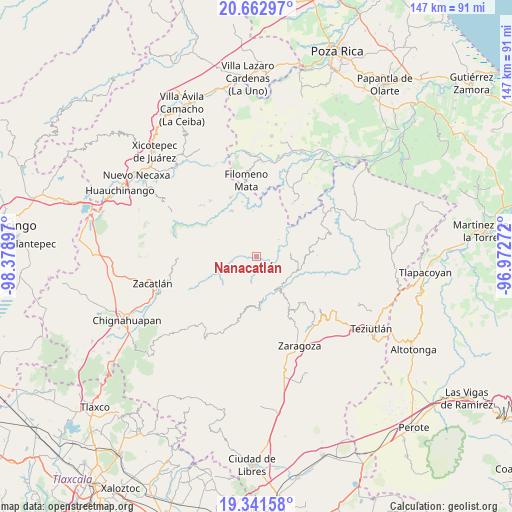
Nanacatlán GPS coordinates[2]
20° 0' 13.176" North, 97° 40' 33.024" West
| Map corner | latitude | longitude |
|---|---|---|
| Upper-left | 20.66297°, | -98.37897° |
| Center: | 20.00366°, | -97.67584° |
| Lower-right: | 19.34158°, | -96.97272° |
| Map W x H: | 146.9×146.9 km | = 91.3×91.3mi |
| max Lat: | 32.7° ⇑43% North |
| Nanacatlán: | 20.00366° |
| min Lat: | ⇓57% South 14.53588° |
| min Long | Nanacatlán | max Long |
| -117.105° | -97.67584° | -86.73105° |
| W 67.6%⇐ | ⇒32.4% E |
Elevation
Elevation of Nanacatlán is 926 m = 3038 ft, and this is 327.7 m = 1075 ft below average elevation for this country.
| Max E: |
3497 m = 11473 ft | 61.2% |
| Avg. | 1253.7 m = 4113 ft | |
| Nanacatlán | 926 m = 3038 ft | |
Min E: |
-1 m = -3 ft | 38.8% |
See also: Mexico elevation on elevation.city.
Geographical zone
Nanacatlán is located in North Torrid zone (between Equator and Tropic of Cancer). Distance of this Northern Tropic circle is 381.7 km =237.2 mi to North.| Distance of | km | miles | from Nanacatlán |
|---|---|---|---|
| North Pole | 7782.9 | 4836.1 | to North |
| Arctic Circle | 5177 | 3216.8 | to North |
| Tropic Cancer | 381.7 | 237.2 | to North |
| Equator | 2224.2 | 1382.1 | to South |


Nearby cities:
15 places around Nanacatlán: (largest is in red/bold)
• Atlequizayan
5.5 km =3.4 mi,  80°
80°
• Chipahuatlán
6.5 km =4 mi,  348°
348°
• Cuarta Sección
3.8 km =2.4 mi,  207°
207°
• Huapalegcan
5.7 km =3.5 mi,  171°
171°
• Hueytlalpan
3.4 km =2.1 mi,  319°
319°
• Huitzilan
4.5 km =2.8 mi, 205°
• Ignacio Allende (Concepción)
4.4 km =2.7 mi, 79°
• Ixtepec
3.9 km =2.4 mi,  53°
53°
• Primera Sección
4.9 km =3 mi,  200°
200°
• San Martín
3.6 km =2.2 mi, 82°
• San Miguel del Progreso
1.8 km =1.1 mi,  148°
148°
• Tuxtla
2.2 km =1.4 mi,  99°
99°
• Zapotitlán
4 km =2.5 mi,  267°
267°
• Zitlala
3.6 km =2.2 mi,  13°
13°
• Zongozotla
6 km =3.7 mi,  243°
243°
Sources, notices
• [Note1] Compared only with cities in Mexico existing in our database
• [Src1] Map data: © OpenStreetMap contributors (CC-BY-SA)
• [Src2] Other city data from geonames.org with taken over terms of usage.
• [Src3] Geographical zone / Annual Mean Temperature by Robert A. Rohde @ Wikipedia
