Tlapehuala geodata
Tlapehuala (Puebla) is a populated place; located in Mexico in America/Mexico_City (GMT-6) time zone. With population of 674 people, there are 12893 cities with bigger population in this country. Compared to other cities in Mexico, 63.7% of cities are located further ↓South; 63.3% of cities are located further ←West and 62.9% of cities have higher elevation than Tlapehuala. Note1


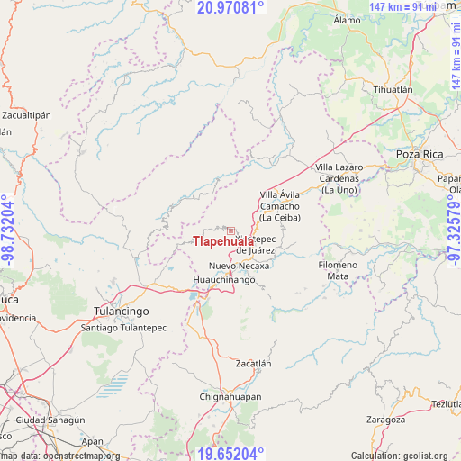
Tlapehuala GPS coordinates[2]
20° 18' 46.188" North, 98° 1' 44.076" West
| Map corner | latitude | longitude |
|---|---|---|
| Upper-left | 20.97081°, | -98.73204° |
| Center: | 20.31283°, | -98.02891° |
| Lower-right: | 19.65204°, | -97.32579° |
| Map W x H: | 146.6×146.6 km | = 91.1×91.1mi |
| max Lat: | 32.7° ⇑36.3% North |
| Tlapehuala: | 20.31283° |
| min Lat: | ⇓63.7% South 14.53588° |
| min Long | Tlapehuala | max Long |
| -117.105° | -98.02891° | -86.73105° |
| W 63.3%⇐ | ⇒36.7% E |
Elevation
Elevation of Tlapehuala is 826 m = 2710 ft, and this is 427.7 m = 1403 ft below average elevation for this country.
| Max E: |
3497 m = 11473 ft | 62.9% |
| Avg. | 1253.7 m = 4113 ft | |
| Tlapehuala | 826 m = 2710 ft | |
Min E: |
-1 m = -3 ft | 37.1% |
See also: Mexico elevation on elevation.city.
Geographical zone
Tlapehuala is located in North Torrid zone (between Equator and Tropic of Cancer). Distance of this Northern Tropic circle is 347.3 km =215.8 mi to North.| Distance of | km | miles | from Tlapehuala |
|---|---|---|---|
| North Pole | 7748.5 | 4814.7 | to North |
| Arctic Circle | 5142.6 | 3195.5 | to North |
| Tropic Cancer | 347.3 | 215.8 | to North |
| Equator | 2258.6 | 1403.4 | to South |


Nearby cities:
15 places around Tlapehuala: (largest is in red/bold)
• Acalapa
6.7 km =4.2 mi,  271°
271°
• Copila
7.2 km =4.5 mi,  231°
231°
• Cuauneutla de la Paz
7.7 km =4.8 mi, 271°
• Cuautepec
3.2 km =2 mi,  334°
334°
• Cuaxtla
8.1 km =5 mi, 325°
• Cueyatla
6.1 km =3.8 mi,  247°
247°
• Duraznotla
7.8 km =4.8 mi,  136°
136°
• El Jericó
5.2 km =3.2 mi,  31°
31°
• El Álamo
6.9 km =4.3 mi,  348°
348°
• Itzatlán
5.2 km =3.2 mi,  62°
62°
• Ozomatlán
3.7 km =2.3 mi,  193°
193°
• Santa María
2.6 km =1.6 mi,  275°
275°
• Tepetzintla de Galeana
3.7 km =2.3 mi,  170°
170°
• Tlacuilotepec
4.4 km =2.7 mi,  289°
289°
• Zacatal
8 km =5 mi,  37°
37°
Sources, notices
• [Note1] Compared only with cities in Mexico existing in our database
• [Src1] Map data: © OpenStreetMap contributors (CC-BY-SA)
• [Src2] Other city data from geonames.org with taken over terms of usage.
• [Src3] Geographical zone / Annual Mean Temperature by Robert A. Rohde @ Wikipedia
