Itzatlán geodata
Itzatlán (Puebla) is a populated place; located in Mexico in America/Mexico_City (GMT-6) time zone. With population of 933 people, there are 9344 cities with bigger population in this country. Compared to other cities in Mexico, 64.2% of cities are located further ↓South; 63.8% of cities are located further ←West and 62.6% of cities have higher elevation than Itzatlán. Note1


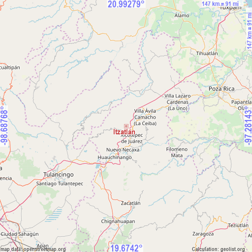
Itzatlán GPS coordinates[2]
20° 20' 5.64" North, 97° 59' 4.38" West
| Map corner | latitude | longitude |
|---|---|---|
| Upper-left | 20.99279°, | -98.68768° |
| Center: | 20.3349°, | -97.98455° |
| Lower-right: | 19.6742°, | -97.28143° |
| Map W x H: | 146.6×146.6 km | = 91.1×91.1mi |
| max Lat: | 32.7° ⇑35.8% North |
| Itzatlán: | 20.3349° |
| min Lat: | ⇓64.2% South 14.53588° |
| min Long | Itzatlán | max Long |
| -117.105° | -97.98455° | -86.73105° |
| W 63.8%⇐ | ⇒36.2% E |
Elevation
Elevation of Itzatlán is 843 m = 2766 ft, and this is 410.7 m = 1347 ft below average elevation for this country.
| Max E: |
3497 m = 11473 ft | 62.6% |
| Avg. | 1253.7 m = 4113 ft | |
| Itzatlán | 843 m = 2766 ft | |
Min E: |
-1 m = -3 ft | 37.4% |
See also: Mexico elevation on elevation.city.
Geographical zone
Itzatlán is located in North Torrid zone (between Equator and Tropic of Cancer). Distance of this Northern Tropic circle is 344.9 km =214.3 mi to North.| Distance of | km | miles | from Itzatlán |
|---|---|---|---|
| North Pole | 7746 | 4813.1 | to North |
| Arctic Circle | 5140.1 | 3193.9 | to North |
| Tropic Cancer | 344.9 | 214.3 | to North |
| Equator | 2261 | 1404.9 | to South |


Nearby cities:
15 places around Itzatlán: (largest is in red/bold)
• Cuautepec
6 km =3.7 mi,  274°
274°
• Duraznotla
8.1 km =5 mi,  174°
174°
• El Jericó
2.7 km =1.7 mi,  317°
317°
• El Álamo
7.4 km =4.6 mi,  306°
306°
• Jalapilla
8 km =5 mi,  62°
62°
• Lomas Verdes
8.9 km =5.5 mi,  155°
155°
• Ozomatlán
8.2 km =5.1 mi,  222°
222°
• San Lorenzo
5.3 km =3.3 mi,  70°
70°
• San Pedro Itztla
8.5 km =5.3 mi,  142°
142°
• Santa María
7.6 km =4.7 mi,  253°
253°
• Tepetzintla de Galeana
7.3 km =4.5 mi,  213°
213°
• Tlacuilotepec
8.8 km =5.5 mi,  263°
263°
• Tlapehuala
5.2 km =3.2 mi,  242°
242°
• Xicotepec de Juárez
7 km =4.3 mi, 159°
• Zacatal
3.9 km =2.4 mi,  4°
4°
Sources, notices
• [Note1] Compared only with cities in Mexico existing in our database
• [Src1] Map data: © OpenStreetMap contributors (CC-BY-SA)
• [Src2] Other city data from geonames.org with taken over terms of usage.
• [Src3] Geographical zone / Annual Mean Temperature by Robert A. Rohde @ Wikipedia
