El Jericó geodata
El Jericó (Puebla) is a populated place; located in Mexico in America/Mexico_City (GMT-6) time zone. With population of 501 people, there are 16785 cities with bigger population in this country. Compared to other cities in Mexico, 64.6% of cities are located further ↓South; 63.6% of cities are located further ←West and 51.8% of cities have higher elevation than El Jericó. Note1


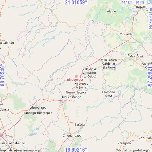
El Jericó GPS coordinates[2]
20° 21' 10.008" North, 98° 0' 8.388" West
| Map corner | latitude | longitude |
|---|---|---|
| Upper-left | 21.01059°, | -98.70546° |
| Center: | 20.35278°, | -98.00233° |
| Lower-right: | 19.69216°, | -97.29921° |
| Map W x H: | 146.6×146.6 km | = 91.1×91.1mi |
| max Lat: | 32.7° ⇑35.4% North |
| El Jericó: | 20.35278° |
| min Lat: | ⇓64.6% South 14.53588° |
| min Long | El Jericó | max Long |
| -117.105° | -98.00233° | -86.73105° |
| W 63.6%⇐ | ⇒36.4% E |
Elevation
Elevation of El Jericó is 1351 m = 4432 ft, and this is 97.3 m = 319 ft above average elevation for this country.
| Max E: |
3497 m = 11473 ft | 51.8% |
| El Jericó | 1351 m 4432 ft | |
| Avg. | 1253.7 m = 4113 ft | |
Min E: |
-1 m = -3 ft | 48.2% |
See also: Mexico elevation on elevation.city.
Geographical zone
El Jericó is located in North Torrid zone (between Equator and Tropic of Cancer). Distance of this Northern Tropic circle is 342.9 km =213.1 mi to North.| Distance of | km | miles | from El Jericó |
|---|---|---|---|
| North Pole | 7744 | 4811.9 | to North |
| Arctic Circle | 5138.2 | 3192.7 | to North |
| Tropic Cancer | 342.9 | 213.1 | to North |
| Equator | 2263 | 1406.2 | to South |


Nearby cities:
15 places around El Jericó: (largest is in red/bold)
• Cuautepec
4.4 km =2.7 mi,  249°
249°
• Cuaxtla
7.7 km =4.8 mi,  286°
286°
• El Rincón
9.2 km =5.7 mi,  357°
357°
• El Álamo
4.7 km =2.9 mi,  300°
300°
• Itzatlán
2.7 km =1.7 mi,  137°
137°
• Jalapilla
9.2 km =5.7 mi,  79°
79°
• Ozomatlán
8.9 km =5.5 mi,  204°
204°
• Papaloctipan
9.3 km =5.8 mi,  31°
31°
• San Lorenzo
6.9 km =4.3 mi,  92°
92°
• Santa María
6.8 km =4.2 mi,  232°
232°
• Tepetzintla de Galeana
8.4 km =5.2 mi, 195°
• Tlacuilotepec
7.5 km =4.7 mi, 246°
• Tlapehuala
5.2 km =3.2 mi,  211°
211°
• Tlaxco
8.3 km =5.2 mi,  340°
340°
• Zacatal
2.9 km =1.8 mi,  48°
48°
Sources, notices
• [Note1] Compared only with cities in Mexico existing in our database
• [Src1] Map data: © OpenStreetMap contributors (CC-BY-SA)
• [Src2] Other city data from geonames.org with taken over terms of usage.
• [Src3] Geographical zone / Annual Mean Temperature by Robert A. Rohde @ Wikipedia
