Cuauhtémoc Barreal geodata
Cuauhtémoc Barreal (Tabasco) is a populated place; located in Mexico in America/Mexico_City (GMT-6) time zone. With population of 917 people, there are 9514 cities with bigger population in this country. Compared to other cities in Mexico, 83.9% of cities are located further ↑North; 90.3% of cities are located further ←West and 80.1% of cities have higher elevation than Cuauhtémoc Barreal. Note1


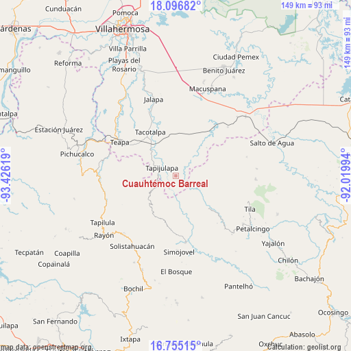
Cuauhtémoc Barreal GPS coordinates[2]
17° 25' 37.992" North, 92° 43' 23.016" West
| Map corner | latitude | longitude |
|---|---|---|
| Upper-left | 18.09682°, | -93.42619° |
| Center: | 17.42722°, | -92.72306° |
| Lower-right: | 16.75515°, | -92.01994° |
| Map W x H: | 149.2×149.2 km | = 92.7×92.7mi |
| max Lat: | 32.7° ⇑83.9% North |
| Cuauhtémoc Barreal: | 17.42722° |
| min Lat: | ⇓16.1% South 14.53588° |
| min Long | Cuauhtémoc Bar | max Long |
| -117.105° | -92.72306° | -86.73105° |
| W 90.3%⇐ | ⇒9.7% E |
Elevation
Elevation of Cuauhtémoc Barreal is 94 m = 308 ft, and this is 1159.7 m = 3805 ft below average elevation for this country.
| Max E: |
3497 m = 11473 ft | 80.1% |
| Avg. | 1253.7 m = 4113 ft | |
| Cuauhtémoc Barreal | 94 m = 308 ft | |
Min E: |
-1 m = -3 ft | 19.9% |
See also: Mexico elevation on elevation.city.
Geographical zone
Cuauhtémoc Barreal is located in North Torrid zone (between Equator and Tropic of Cancer). Distance of this Northern Tropic circle is 668.2 km =415.2 mi to North.| Distance of | km | miles | from Cuauhtémoc Barreal |
|---|---|---|---|
| North Pole | 8069.3 | 5014 | to North |
| Arctic Circle | 5463.4 | 3394.8 | to North |
| Tropic Cancer | 668.2 | 415.2 | to North |
| Equator | 1937.7 | 1204 | to South |


Nearby cities:
15 places around Cuauhtémoc Barreal: (largest is in red/bold)
• Amatán
11.8 km =7.3 mi,  239°
239°
• Campamento el Mirador
9.8 km =6.1 mi,  151°
151°
• Cristóbal Colón
10.8 km =6.7 mi,  138°
138°
• Cuitláhuac
7.8 km =4.8 mi,  186°
186°
• El Bebedero
8.6 km =5.3 mi,  112°
112°
• Jesús Carranza
7.5 km =4.7 mi,  103°
103°
• Libertad
2.1 km =1.3 mi,  155°
155°
• Moyos
11.5 km =7.1 mi,  131°
131°
• Oxolotán
6 km =3.7 mi,  207°
207°
• Puxcatán
4.6 km =2.9 mi,  55°
55°
• Raya Zaragoza
4.7 km =2.9 mi,  120°
120°
• Tapijulapa
7.1 km =4.4 mi,  303°
303°
• Unión Juárez
10.9 km =6.8 mi, 114°
• Xicoténcatl
10.3 km =6.4 mi,  10°
10°
• Zunu y Patastal
10.8 km =6.7 mi, 298°
Sources, notices
• [Note1] Compared only with cities in Mexico existing in our database
• [Src1] Map data: © OpenStreetMap contributors (CC-BY-SA)
• [Src2] Other city data from geonames.org with taken over terms of usage.
• [Src3] Geographical zone / Annual Mean Temperature by Robert A. Rohde @ Wikipedia
