San José Alchichica geodata
San José Alchichica (Puebla) is a populated place; located in Mexico in America/Mexico_City (GMT-6) time zone. With population of 2,527 people, there are 3508 cities with bigger population in this country. Compared to other cities in Mexico, 55.4% of cities are located further ↑North; 70.7% of cities are located further ←West and 87.8% of cities have lower elevation than San José Alchichica. Note1


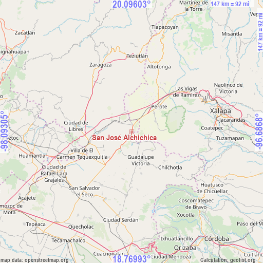
San José Alchichica GPS coordinates[2]
19° 26' 3.588" North, 97° 23' 23.712" West
| Map corner | latitude | longitude |
|---|---|---|
| Upper-left | 20.09603°, | -98.09305° |
| Center: | 19.43433°, | -97.38992° |
| Lower-right: | 18.76993°, | -96.6868° |
| Map W x H: | 147.4×147.5 km | = 91.6×91.7mi |
| max Lat: | 32.7° ⇑55.4% North |
| San José Alchichica: | 19.43433° |
| min Lat: | ⇓44.6% South 14.53588° |
| min Long | San José Alchi | max Long |
| -117.105° | -97.38992° | -86.73105° |
| W 70.7%⇐ | ⇒29.3% E |
Elevation
Elevation of San José Alchichica is 2335 m = 7661 ft, and this is 1081.3 m = 3548 ft above average elevation for this country.
| Max E: |
3497 m = 11473 ft | 12.2% |
| San José Alchichica | 2335 m 7661 ft | |
| Avg. | 1253.7 m = 4113 ft | |
Min E: |
-1 m = -3 ft | 87.8% |
See also: Mexico elevation on elevation.city.
Geographical zone
San José Alchichica is located in North Torrid zone (between Equator and Tropic of Cancer). Distance of this Northern Tropic circle is 445 km =276.5 mi to North.| Distance of | km | miles | from San José Alchichica |
|---|---|---|---|
| North Pole | 7846.2 | 4875.4 | to North |
| Arctic Circle | 5240.3 | 3256.2 | to North |
| Tropic Cancer | 445 | 276.5 | to North |
| Equator | 2160.9 | 1342.7 | to South |


Nearby cities:
15 places around San José Alchichica: (largest is in red/bold)
• Chichicuautla
4.9 km =3 mi,  184°
184°
• El Progreso
11.9 km =7.4 mi,  117°
117°
• Francisco I. Madero
16.2 km =10.1 mi,  50°
50°
• Guadalupe Sarabia
11.4 km =7.1 mi,  339°
339°
• Hacienda Nueva (San Pedro el Águila)
11.4 km =7.1 mi,  192°
192°
• Itzoteno
5.4 km =3.4 mi,  248°
248°
• La Gloria
12.1 km =7.5 mi,  110°
110°
• Maravillas
13 km =8.1 mi,  141°
141°
• Quechulac
8.1 km =5 mi,  147°
147°
• Techachalco
7.7 km =4.8 mi,  218°
218°
• Tepeyehualco de Hidalgo
12.3 km =7.6 mi,  299°
299°
• Tetipanapa
15.7 km =9.8 mi,  283°
283°
• Tlalconteno
15.1 km =9.4 mi,  83°
83°
• Xaltepec
6.9 km =4.3 mi, 148°
• Zalayeta (Alchichica y el Bordo)
2.6 km =1.6 mi, 184°
Sources, notices
• [Note1] Compared only with cities in Mexico existing in our database
• [Src1] Map data: © OpenStreetMap contributors (CC-BY-SA)
• [Src2] Other city data from geonames.org with taken over terms of usage.
• [Src3] Geographical zone / Annual Mean Temperature by Robert A. Rohde @ Wikipedia
