Apaxtla de Castrejón geodata
Apaxtla de Castrejón (Guerrero) is a seat of a second-order administrative division; located in Mexico in America/Mexico_City (GMT-6) time zone. With population of 7,037 people, there are 1320 cities with bigger population in this country. Compared to other cities in Mexico, 77.2% of cities are located further ↑North; 63% of cities are located further →East and 54.7% of cities have higher elevation than Apaxtla de Castrejón. Note1
Current local time in Apaxtla de Castrejón:
08:26 AM, WednesdayDifference from your time zone: hours


Apaxtla de Castrejón GPS coordinates[2]
18° 7' 52.572" North, 99° 55' 57.18" West
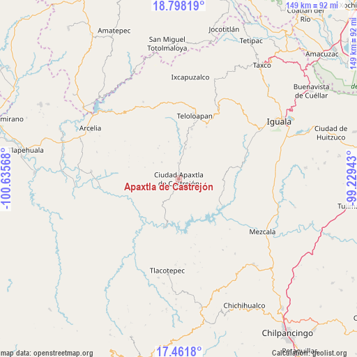
| Map corner | latitude | longitude |
|---|---|---|
| Upper-left | 18.79819°, | -100.63568° |
| Center: | 18.13127°, | -99.93255° |
| Lower-right: | 17.4618°, | -99.22943° |
| Map W x H: | 148.6×148.6 km | = 92.3×92.3mi |
| max Lat: | 32.7° ⇑77.2% North |
| Apaxtla de Castrejón: | 18.13127° |
| min Lat: | ⇓22.8% South 14.53588° |
| min Long | Apaxtla de Cast | max Long |
| -117.105° | -99.93255° | -86.73105° |
| W 37%⇐ | ⇒63% E |
Elevation
Elevation of Apaxtla de Castrejón is 1213 m = 3980 ft, and this is 40.7 m = 134 ft below average elevation for this country.
| Max E: |
3497 m = 11473 ft | 54.7% |
| Avg. | 1253.7 m = 4113 ft | |
| Apaxtla de Castrejón | 1213 m = 3980 ft | |
Min E: |
-1 m = -3 ft | 45.3% |
See also: Mexico elevation on elevation.city.
Geographical zone
Apaxtla de Castrejón is located in North Torrid zone (between Equator and Tropic of Cancer). Distance of this Northern Tropic circle is 589.9 km =366.5 mi to North.| Distance of | km | miles | from Apaxtla de Castrejón |
|---|---|---|---|
| North Pole | 7991.1 | 4965.4 | to North |
| Arctic Circle | 5385.2 | 3346.2 | to North |
| Tropic Cancer | 589.9 | 366.5 | to North |
| Equator | 2016 | 1252.7 | to South |


Nearby cities:
15 places around Apaxtla de Castrejón: (largest is in red/bold)
• Acatempan
21.4 km =13.3 mi,  14°
14°
• Ahuaxotitla
16 km =9.9 mi,  83°
83°
• Apetlanca
17.4 km =10.8 mi,  60°
60°
• Cuaxilotla
9.7 km =6 mi, 62°
• Cuetzala del Progreso
10.6 km =6.6 mi,  87°
87°
• El Calvario
21.5 km =13.4 mi,  35°
35°
• Los Sauces
18.2 km =11.3 mi,  34°
34°
• Nuevo Balsas
21.4 km =13.3 mi,  120°
120°
• Nuevo Poblado el Caracol
21.4 km =13.3 mi,  206°
206°
• Oxtotitlán
6.5 km =4 mi,  0°
0°
• Tehuixtla
20.6 km =12.8 mi,  359°
359°
• Tianquizolco
21.4 km =13.3 mi, 61°
• Tlacaquipa
12.4 km =7.7 mi, 31°
• Tlanipatlán
19.8 km =12.3 mi, 80°
• Totoltepec
19.8 km =12.3 mi,  324°
324°
Sources, notices
• [Note1] Compared only with cities in Mexico existing in our database
• [Src1] Map data: © OpenStreetMap contributors (CC-BY-SA)
• [Src2] Other city data from geonames.org with taken over terms of usage.
• [Src3] Geographical zone / Annual Mean Temperature by Robert A. Rohde @ Wikipedia
