San Miguel geodata
San Miguel (Hidalgo) is a populated place; located in Mexico in America/Mexico_City (GMT-6) time zone. With population of 520 people, there are 16208 cities with bigger population in this country. Compared to other cities in Mexico, 73.6% of cities are located further ↓South; 56.7% of cities are located further ←West and 60.5% of cities have higher elevation than San Miguel. Note1


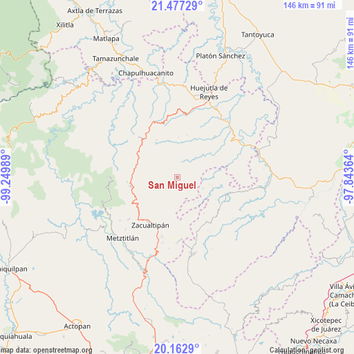
San Miguel GPS coordinates[2]
20° 49' 17.508" North, 98° 32' 48.336" West
| Map corner | latitude | longitude |
|---|---|---|
| Upper-left | 21.47729°, | -99.24989° |
| Center: | 20.82153°, | -98.54676° |
| Lower-right: | 20.1629°, | -97.84364° |
| Map W x H: | 146.1×146.1 km | = 90.8×90.8mi |
| max Lat: | 32.7° ⇑26.4% North |
| San Miguel: | 20.82153° |
| min Lat: | ⇓73.6% South 14.53588° |
| min Long | San Miguel | max Long |
| -117.105° | -98.54676° | -86.73105° |
| W 56.7%⇐ | ⇒43.3% E |
Elevation
Elevation of San Miguel is 973 m = 3192 ft, and this is 280.7 m = 921 ft below average elevation for this country.
| Max E: |
3497 m = 11473 ft | 60.5% |
| Avg. | 1253.7 m = 4113 ft | |
| San Miguel | 973 m = 3192 ft | |
Min E: |
-1 m = -3 ft | 39.5% |
See also: Mexico elevation on elevation.city.
Geographical zone
San Miguel is located in North Torrid zone (between Equator and Tropic of Cancer). Distance of this Northern Tropic circle is 290.8 km =180.7 mi to North.| Distance of | km | miles | from San Miguel |
|---|---|---|---|
| North Pole | 7691.9 | 4779.5 | to North |
| Arctic Circle | 5086 | 3160.3 | to North |
| Tropic Cancer | 290.8 | 180.7 | to North |
| Equator | 2315.1 | 1438.5 | to South |


Nearby cities:
15 places around San Miguel: (largest is in red/bold)
• Ahuacatlán
12.7 km =7.9 mi,  306°
306°
• Apachitla
12.7 km =7.9 mi,  146°
146°
• Atempa
9.1 km =5.7 mi,  40°
40°
• Calnali
9.3 km =5.8 mi,  334°
334°
• Coacoaco
11.4 km =7.1 mi,  86°
86°
• Coamitla
10.3 km =6.4 mi,  30°
30°
• Ilamatlán
11.7 km =7.3 mi,  112°
112°
• Ixcotitlán
7.4 km =4.6 mi,  166°
166°
• Polintotla
7.5 km =4.7 mi, 147°
• San Andrés (San Andrés Chichayotla)
11.8 km =7.3 mi,  351°
351°
• Texcaco
7.5 km =4.7 mi,  285°
285°
• Tuzancoac
3.8 km =2.4 mi, 347°
• Xalacahuantla
6.9 km =4.3 mi,  124°
124°
• Xochimilco
5.3 km =3.3 mi,  137°
137°
• Zacatipán
4.1 km =2.5 mi,  64°
64°
Sources, notices
• [Note1] Compared only with cities in Mexico existing in our database
• [Src1] Map data: © OpenStreetMap contributors (CC-BY-SA)
• [Src2] Other city data from geonames.org with taken over terms of usage.
• [Src3] Geographical zone / Annual Mean Temperature by Robert A. Rohde @ Wikipedia
