Venta Grande geodata
Venta Grande (Puebla) is a populated place; located in Mexico in America/Mexico_City (GMT-6) time zone. With population of 1,528 people, there are 5648 cities with bigger population in this country. Compared to other cities in Mexico, 59.6% of cities are located further ↓South; 62.5% of cities are located further ←West and 79.5% of cities have lower elevation than Venta Grande. Note1


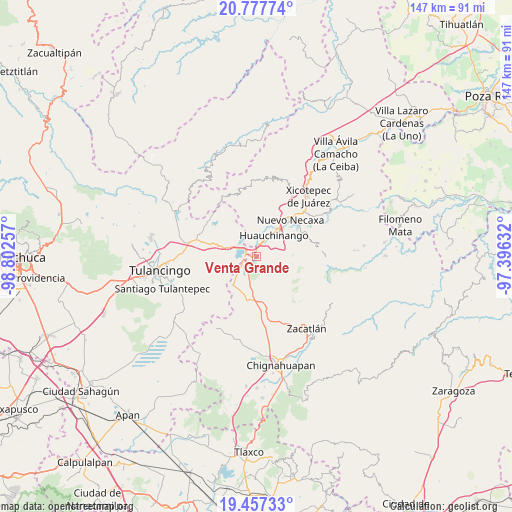
Venta Grande GPS coordinates[2]
20° 7' 8.148" North, 98° 5' 57.984" West
| Map corner | latitude | longitude |
|---|---|---|
| Upper-left | 20.77774°, | -98.80257° |
| Center: | 20.11893°, | -98.09944° |
| Lower-right: | 19.45733°, | -97.39632° |
| Map W x H: | 146.8×146.8 km | = 91.2×91.2mi |
| max Lat: | 32.7° ⇑40.4% North |
| Venta Grande: | 20.11893° |
| min Lat: | ⇓59.6% South 14.53588° |
| min Long | Venta Grande | max Long |
| -117.105° | -98.09944° | -86.73105° |
| W 62.5%⇐ | ⇒37.5% E |
Elevation
Elevation of Venta Grande is 2128 m = 6982 ft, and this is 874.3 m = 2868 ft above average elevation for this country.
| Max E: |
3497 m = 11473 ft | 20.5% |
| Venta Grande | 2128 m 6982 ft | |
| Avg. | 1253.7 m = 4113 ft | |
Min E: |
-1 m = -3 ft | 79.5% |
See also: Mexico elevation on elevation.city.
Geographical zone
Venta Grande is located in North Torrid zone (between Equator and Tropic of Cancer). Distance of this Northern Tropic circle is 368.9 km =229.2 mi to North.| Distance of | km | miles | from Venta Grande |
|---|---|---|---|
| North Pole | 7770 | 4828.1 | to North |
| Arctic Circle | 5164.2 | 3208.9 | to North |
| Tropic Cancer | 368.9 | 229.2 | to North |
| Equator | 2237 | 1390 | to South |


Nearby cities:
15 places around Venta Grande: (largest is in red/bold)
• Beristain
4.4 km =2.7 mi,  231°
231°
• Camotepec
8.6 km =5.3 mi,  157°
157°
• Cuacuila
9.2 km =5.7 mi,  50°
50°
• Cuahuihuitzotitla
9.2 km =5.7 mi,  348°
348°
• El Tejocotal
3.7 km =2.3 mi,  308°
308°
• Huauchinango
7.7 km =4.8 mi,  37°
37°
• La Boveda
2.7 km =1.7 mi,  284°
284°
• Laguna Seca
9.2 km =5.7 mi,  197°
197°
• Los Reyes
7.9 km =4.9 mi,  300°
300°
• Mesa de Capulines
2.1 km =1.3 mi,  249°
249°
• Ocpaco
7.4 km =4.6 mi,  65°
65°
• Teopancingo
4.2 km =2.6 mi,  131°
131°
• Tepepa
7.7 km =4.8 mi, 282°
• Tlacomulco
4.4 km =2.7 mi,  330°
330°
• Xilocuautla
8.3 km =5.2 mi, 73°
Sources, notices
• [Note1] Compared only with cities in Mexico existing in our database
• [Src1] Map data: © OpenStreetMap contributors (CC-BY-SA)
• [Src2] Other city data from geonames.org with taken over terms of usage.
• [Src3] Geographical zone / Annual Mean Temperature by Robert A. Rohde @ Wikipedia
