Huitziltepec geodata
Huitziltepec (Guerrero) is a populated place; located in Mexico in America/Mexico_City (GMT-6) time zone. With population of 4,513 people, there are 2038 cities with bigger population in this country. Compared to other cities in Mexico, 80.9% of cities are located further ↑North; 56.7% of cities are located further →East and 52.4% of cities have higher elevation than Huitziltepec. Note1


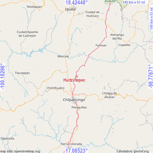
Huitziltepec GPS coordinates[2]
17° 45' 21.96" North, 99° 28' 47.388" West
| Map corner | latitude | longitude |
|---|---|---|
| Upper-left | 18.42446°, | -100.18296° |
| Center: | 17.7561°, | -99.47983° |
| Lower-right: | 17.08523°, | -98.77671° |
| Map W x H: | 148.9×148.9 km | = 92.5×92.5mi |
| max Lat: | 32.7° ⇑80.9% North |
| Huitziltepec: | 17.7561° |
| min Lat: | ⇓19.1% South 14.53588° |
| min Long | Huitziltepec | max Long |
| -117.105° | -99.47983° | -86.73105° |
| W 43.3%⇐ | ⇒56.7% E |
Elevation
Elevation of Huitziltepec is 1318 m = 4324 ft, and this is 64.3 m = 211 ft above average elevation for this country.
| Max E: |
3497 m = 11473 ft | 52.4% |
| Huitziltepec | 1318 m 4324 ft | |
| Avg. | 1253.7 m = 4113 ft | |
Min E: |
-1 m = -3 ft | 47.6% |
See also: Mexico elevation on elevation.city.
Geographical zone
Huitziltepec is located in North Torrid zone (between Equator and Tropic of Cancer). Distance of this Northern Tropic circle is 631.6 km =392.5 mi to North.| Distance of | km | miles | from Huitziltepec |
|---|---|---|---|
| North Pole | 8032.8 | 4991.3 | to North |
| Arctic Circle | 5426.9 | 3372.1 | to North |
| Tropic Cancer | 631.6 | 392.5 | to North |
| Equator | 1974.3 | 1226.8 | to South |


Nearby cities:
15 places around Huitziltepec: (largest is in red/bold)
• Acatempa
17.4 km =10.8 mi,  136°
136°
• Apango
16 km =9.9 mi,  95°
95°
• Atliaca
16.1 km =10 mi, 136°
• Atlixtac
20.2 km =12.6 mi,  232°
232°
• Axaxacualco
5.6 km =3.5 mi,  19°
19°
• El Palmar
17.6 km =10.9 mi, 227°
• Hueyitlalpan
21.5 km =13.4 mi,  114°
114°
• San Agustín Oapan
22.3 km =13.9 mi,  11°
11°
• San Juan Tetelcingo
18.9 km =11.7 mi,  347°
347°
• San Marcos Oacatzingo
19.8 km =12.3 mi,  359°
359°
• Tlamamacan
19.2 km =11.9 mi, 345°
• Tlanipatla
6.5 km =4 mi,  27°
27°
• Xochipala
18 km =11.2 mi,  290°
290°
• Zotoltitlán
20.5 km =12.7 mi, 103°
• Zumpango del Río
12.4 km =7.7 mi,  203°
203°
Sources, notices
• [Note1] Compared only with cities in Mexico existing in our database
• [Src1] Map data: © OpenStreetMap contributors (CC-BY-SA)
• [Src2] Other city data from geonames.org with taken over terms of usage.
• [Src3] Geographical zone / Annual Mean Temperature by Robert A. Rohde @ Wikipedia
