Zumpango del Río geodata
Zumpango del Río (Guerrero) is a populated place; located in Mexico in America/Mexico_City (GMT-6) time zone. With population of 24,719 people, there are 411 cities with bigger population in this country. Compared to other cities in Mexico, 81.7% of cities are located further ↑North; 57.3% of cities are located further →East and 59.2% of cities have higher elevation than Zumpango del Río. Note1


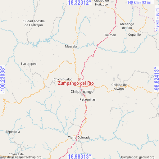
Zumpango del Río GPS coordinates[2]
17° 39' 15.732" North, 99° 31' 38.1" West
| Map corner | latitude | longitude |
|---|---|---|
| Upper-left | 18.32312°, | -100.23038° |
| Center: | 17.65437°, | -99.52725° |
| Lower-right: | 16.98313°, | -98.82413° |
| Map W x H: | 149×149 km | = 92.6×92.6mi |
| max Lat: | 32.7° ⇑81.7% North |
| Zumpango del Río: | 17.65437° |
| min Lat: | ⇓18.3% South 14.53588° |
| min Long | Zumpango del R� | max Long |
| -117.105° | -99.52725° | -86.73105° |
| W 42.7%⇐ | ⇒57.3% E |
Elevation
Elevation of Zumpango del Río is 1040 m = 3412 ft, and this is 213.7 m = 701 ft below average elevation for this country.
| Max E: |
3497 m = 11473 ft | 59.2% |
| Avg. | 1253.7 m = 4113 ft | |
| Zumpango del Río | 1040 m = 3412 ft | |
Min E: |
-1 m = -3 ft | 40.8% |
See also: Mexico elevation on elevation.city.
Geographical zone
Zumpango del Río is located in North Torrid zone (between Equator and Tropic of Cancer). Distance of this Northern Tropic circle is 642.9 km =399.5 mi to North.| Distance of | km | miles | from Zumpango del Río |
|---|---|---|---|
| North Pole | 8044.1 | 4998.4 | to North |
| Arctic Circle | 5438.2 | 3379.1 | to North |
| Tropic Cancer | 642.9 | 399.5 | to North |
| Equator | 1963 | 1219.8 | to South |


Nearby cities:
15 places around Zumpango del Río: (largest is in red/bold)
• Acatempa
17.1 km =10.6 mi,  94°
94°
• Amojileca
10.4 km =6.5 mi,  205°
205°
• Atliaca
16.2 km =10.1 mi, 91°
• Atlixtac
11 km =6.8 mi,  264°
264°
• Axaxacualco
18 km =11.2 mi,  22°
22°
• Chichihualco
15.8 km =9.8 mi,  271°
271°
• Chilpancingo
11.8 km =7.3 mi,  168°
168°
• El Palmar
8 km =5 mi, 266°
• Huitziltepec
12.4 km =7.7 mi, 23°
• Petaquillas
20.1 km =12.5 mi,  158°
158°
• San Vicente
22.8 km =14.2 mi,  226°
226°
• Tepechicotlán
22.4 km =13.9 mi,  148°
148°
• Tixtla de Guerrero
16.8 km =10.4 mi,  125°
125°
• Tlanipatla
18.9 km =11.7 mi,  25°
25°
• Xochipala
21.2 km =13.2 mi,  325°
325°
Sources, notices
• [Note1] Compared only with cities in Mexico existing in our database
• [Src1] Map data: © OpenStreetMap contributors (CC-BY-SA)
• [Src2] Other city data from geonames.org with taken over terms of usage.
• [Src3] Geographical zone / Annual Mean Temperature by Robert A. Rohde @ Wikipedia
