Balleza geodata
Balleza (Chihuahua) is a seat of a second-order administrative division; located in Mexico in America/Chihuahua (GMT-6) time zone. In our database, there are 16903 cities with bigger population. Compared to other cities in Mexico, 96.2% of cities are located further ↓South; 94% of cities are located further →East and 54.5% of cities have lower elevation than Balleza. Note1


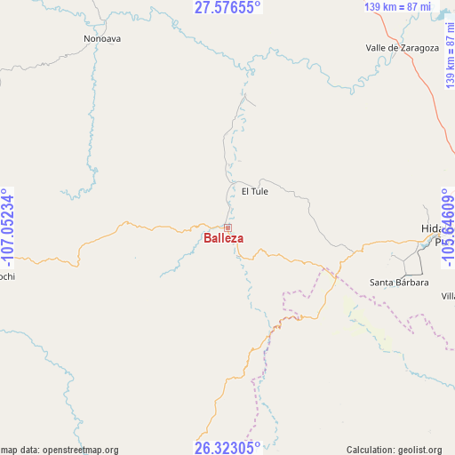
Balleza GPS coordinates[2]
26° 57' 5.544" North, 106° 20' 57.156" West
| Map corner | latitude | longitude |
|---|---|---|
| Upper-left | 27.57655°, | -107.05234° |
| Center: | 26.95154°, | -106.34921° |
| Lower-right: | 26.32305°, | -105.64609° |
| Map W x H: | 139.4×139.4 km | = 86.6×86.6mi |
| max Lat: | 32.7° ⇑3.8% North |
| Balleza: | 26.95154° |
| min Lat: | ⇓96.2% South 14.53588° |
| min Long | Balleza | max Long |
| -117.105° | -106.34921° | -86.73105° |
| W 6%⇐ | ⇒94% E |
Elevation
Elevation of Balleza is 1574 m = 5164 ft, and this is 320.3 m = 1051 ft above average elevation for this country.
| Max E: |
3497 m = 11473 ft | 45.5% |
| Balleza | 1574 m 5164 ft | |
| Avg. | 1253.7 m = 4113 ft | |
Min E: |
-1 m = -3 ft | 54.5% |
See also: Mexico elevation on elevation.city.
Geographical zone
Balleza is located in North temperate zone (between Tropic of Cancer and the Arctic Circle). Distance of this Northern Tropic circle is 390.8 km =242.8 mi to South.| Distance of | km | miles | from Balleza |
|---|---|---|---|
| North Pole | 7010.3 | 4356 | to North |
| Arctic Circle | 4404.4 | 2736.8 | to North |
| Tropic Cancer | 390.8 | 242.8 | to South |
| Equator | 2996.7 | 1862.1 | to South |


Nearby cities:
15 places around Balleza: (largest is in red/bold)
• Ejido El Vergel
53.5 km =33.2 mi,  183°
183°
• El Oro
50.6 km =31.4 mi,  101°
101°
• El Tule
14.1 km =8.8 mi,  36°
36°
• Guachochi
73.4 km =45.6 mi,  258°
258°
• Huejotitán
20.6 km =12.8 mi,  55°
55°
• Mariano Balleza
0.4 km =0.2 mi,  49°
49°
• Matamoros
78.7 km =48.9 mi,  105°
105°
• Nonoava
69.4 km =43.1 mi,  326°
326°
• Norogachi
85.3 km =53 mi,  294°
294°
• Parral
67.7 km =42.1 mi,  92°
92°
• San Pedro de Chinatú (Ranchería San Pedro)
89.4 km =55.6 mi,  197°
197°
• Santa Bárbara
55 km =34.2 mi, 107°
• Talamantes
90.6 km =56.3 mi, 92°
• Valle de Zaragoza
77.1 km =47.9 mi, 43°
• Valle del Rosario
41.2 km =25.6 mi,  7°
7°
Sources, notices
• [Note1] Compared only with cities in Mexico existing in our database
• [Src1] Map data: © OpenStreetMap contributors (CC-BY-SA)
• [Src2] Other city data from geonames.org with taken over terms of usage.
• [Src3] Geographical zone / Annual Mean Temperature by Robert A. Rohde @ Wikipedia
