Mariano Balleza geodata
Mariano Balleza (Chihuahua) is a populated place; located in Mexico in America/Chihuahua (GMT-6) time zone. With population of 2,087 people, there are 4183 cities with bigger population in this country. Compared to other cities in Mexico, 96.2% of cities are located further ↓South; 94% of cities are located further →East and 54.3% of cities have lower elevation than Mariano Balleza. Note1


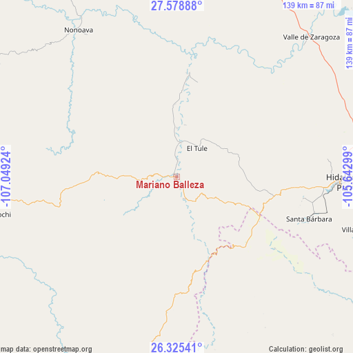
Mariano Balleza GPS coordinates[2]
26° 57' 14.004" North, 106° 20' 45.996" West
| Map corner | latitude | longitude |
|---|---|---|
| Upper-left | 27.57888°, | -107.04924° |
| Center: | 26.95389°, | -106.34611° |
| Lower-right: | 26.32541°, | -105.64299° |
| Map W x H: | 139.4×139.4 km | = 86.6×86.6mi |
| max Lat: | 32.7° ⇑3.8% North |
| Mariano Balleza: | 26.95389° |
| min Lat: | ⇓96.2% South 14.53588° |
| min Long | Mariano Balleza | max Long |
| -117.105° | -106.34611° | -86.73105° |
| W 6%⇐ | ⇒94% E |
Elevation
Elevation of Mariano Balleza is 1568 m = 5144 ft, and this is 314.3 m = 1031 ft above average elevation for this country.
| Max E: |
3497 m = 11473 ft | 45.7% |
| Mariano Balleza | 1568 m 5144 ft | |
| Avg. | 1253.7 m = 4113 ft | |
Min E: |
-1 m = -3 ft | 54.3% |
See also: Mexico elevation on elevation.city.
Geographical zone
Mariano Balleza is located in North temperate zone (between Tropic of Cancer and the Arctic Circle). Distance of this Northern Tropic circle is 391.1 km =243 mi to South.| Distance of | km | miles | from Mariano Balleza |
|---|---|---|---|
| North Pole | 7010.1 | 4355.9 | to North |
| Arctic Circle | 4404.2 | 2736.6 | to North |
| Tropic Cancer | 391.1 | 243 | to South |
| Equator | 2997 | 1862.2 | to South |


Nearby cities:
15 places around Mariano Balleza: (largest is in red/bold)
• Balleza
0.4 km =0.2 mi,  229°
229°
• Ejido El Vergel
53.8 km =33.4 mi,  183°
183°
• El Oro
50.4 km =31.3 mi,  101°
101°
• El Tule
13.7 km =8.5 mi,  35°
35°
• Guachochi
73.8 km =45.9 mi,  258°
258°
• Huejotitán
20.2 km =12.6 mi,  55°
55°
• Matamoros
78.4 km =48.7 mi,  105°
105°
• Nonoava
69.4 km =43.1 mi,  326°
326°
• Norogachi
85.4 km =53.1 mi,  294°
294°
• Parral
67.4 km =41.9 mi,  92°
92°
• San Pedro de Chinatú (Ranchería San Pedro)
89.7 km =55.7 mi,  197°
197°
• Santa Bárbara
54.8 km =34.1 mi, 107°
• Talamantes
90.3 km =56.1 mi, 92°
• Valle de Zaragoza
76.7 km =47.7 mi, 43°
• Valle del Rosario
40.9 km =25.4 mi,  7°
7°
Sources, notices
• [Note1] Compared only with cities in Mexico existing in our database
• [Src1] Map data: © OpenStreetMap contributors (CC-BY-SA)
• [Src2] Other city data from geonames.org with taken over terms of usage.
• [Src3] Geographical zone / Annual Mean Temperature by Robert A. Rohde @ Wikipedia
