Norogachi geodata
Norogachi (Chihuahua) is a populated place; located in Mexico in America/Chihuahua (GMT-6) time zone. With population of 900 people, there are 9690 cities with bigger population in this country. Compared to other cities in Mexico, 96.6% of cities are located further ↓South; 94.5% of cities are located further →East and 78.5% of cities have lower elevation than Norogachi. Note1


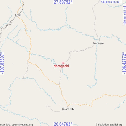
Norogachi GPS coordinates[2]
27° 16' 27.588" North, 107° 7' 51.024" West
| Map corner | latitude | longitude |
|---|---|---|
| Upper-left | 27.89752°, | -107.83397° |
| Center: | 27.27433°, | -107.13084° |
| Lower-right: | 26.64763°, | -106.42772° |
| Map W x H: | 139×139 km | = 86.4×86.4mi |
| max Lat: | 32.7° ⇑3.4% North |
| Norogachi: | 27.27433° |
| min Lat: | ⇓96.6% South 14.53588° |
| min Long | Norogachi | max Long |
| -117.105° | -107.13084° | -86.73105° |
| W 5.5%⇐ | ⇒94.5% E |
Elevation
Elevation of Norogachi is 2099 m = 6886 ft, and this is 845.3 m = 2773 ft above average elevation for this country.
| Max E: |
3497 m = 11473 ft | 21.5% |
| Norogachi | 2099 m 6886 ft | |
| Avg. | 1253.7 m = 4113 ft | |
Min E: |
-1 m = -3 ft | 78.5% |
See also: Mexico elevation on elevation.city.
Geographical zone
Norogachi is located in North temperate zone (between Tropic of Cancer and the Arctic Circle). Distance of this Northern Tropic circle is 426.7 km =265.1 mi to South.| Distance of | km | miles | from Norogachi |
|---|---|---|---|
| North Pole | 6974.4 | 4333.7 | to North |
| Arctic Circle | 4368.6 | 2714.5 | to North |
| Tropic Cancer | 426.7 | 265.1 | to South |
| Equator | 3032.6 | 1884.4 | to South |


Nearby cities:
15 places around Norogachi: (largest is in red/bold)
• Batopilas
66.3 km =41.2 mi,  245°
245°
• Bocoyna
77.6 km =48.2 mi,  324°
324°
• Carichí
71.8 km =44.6 mi,  5°
5°
• Creel
72.6 km =45.1 mi, 316°
• Guachochi
50.8 km =31.6 mi,  173°
173°
• Guapalaina
76.3 km =47.4 mi,  261°
261°
• Nonoava
44.9 km =27.9 mi,  60°
60°
• Polanco (Ranchería Mineral Polanco)
70 km =43.5 mi,  225°
225°
• Samachique
40.4 km =25.1 mi,  274°
274°
• San Francisco de Borja
82.4 km =51.2 mi,  32°
32°
• San Rafael
79 km =49.1 mi,  288°
288°
• Sisoguichi
67 km =41.6 mi,  327°
327°
• Urique
77.8 km =48.3 mi, 264°
• Valle del Rosario
82.7 km =51.4 mi,  86°
86°
• Yoquivo
48.7 km =30.3 mi,  235°
235°
Sources, notices
• [Note1] Compared only with cities in Mexico existing in our database
• [Src1] Map data: © OpenStreetMap contributors (CC-BY-SA)
• [Src2] Other city data from geonames.org with taken over terms of usage.
• [Src3] Geographical zone / Annual Mean Temperature by Robert A. Rohde @ Wikipedia
