Batopilas geodata
Batopilas (Chihuahua) is a seat of a second-order administrative division; located in Mexico in America/Chihuahua (GMT-6) time zone. With population of 1,220 people, there are 7122 cities with bigger population in this country. Compared to other cities in Mexico, 96.4% of cities are located further ↓South; 95.3% of cities are located further →East and 66% of cities have higher elevation than Batopilas. Note1


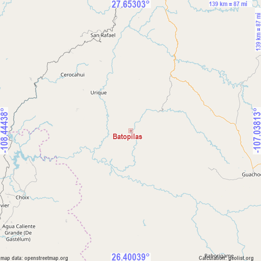
Batopilas GPS coordinates[2]
27° 1' 42.456" North, 107° 44' 28.5" West
| Map corner | latitude | longitude |
|---|---|---|
| Upper-left | 27.65303°, | -108.44438° |
| Center: | 27.02846°, | -107.74125° |
| Lower-right: | 26.40039°, | -107.03813° |
| Map W x H: | 139.3×139.3 km | = 86.6×86.6mi |
| max Lat: | 32.7° ⇑3.6% North |
| Batopilas: | 27.02846° |
| min Lat: | ⇓96.4% South 14.53588° |
| min Long | Batopilas | max Long |
| -117.105° | -107.74125° | -86.73105° |
| W 4.7%⇐ | ⇒95.3% E |
Elevation
Elevation of Batopilas is 636 m = 2087 ft, and this is 617.7 m = 2027 ft below average elevation for this country.
| Max E: |
3497 m = 11473 ft | 66% |
| Avg. | 1253.7 m = 4113 ft | |
| Batopilas | 636 m = 2087 ft | |
Min E: |
-1 m = -3 ft | 34% |
See also: Mexico elevation on elevation.city.
Geographical zone
Batopilas is located in North temperate zone (between Tropic of Cancer and the Arctic Circle). Distance of this Northern Tropic circle is 399.4 km =248.2 mi to South.| Distance of | km | miles | from Batopilas |
|---|---|---|---|
| North Pole | 7001.8 | 4350.7 | to North |
| Arctic Circle | 4395.9 | 2731.5 | to North |
| Tropic Cancer | 399.4 | 248.2 | to South |
| Equator | 3005.3 | 1867.4 | to South |


Nearby cities:
15 places around Batopilas: (largest is in red/bold)
• Bahuichivo
53.2 km =33.1 mi,  322°
322°
• Bajosori
75.1 km =46.7 mi,  239°
239°
• Cerocahui
43.2 km =26.8 mi,  314°
314°
• Choix
68 km =42.3 mi, 238°
• Guachochi
70 km =43.5 mi,  109°
109°
• Guadalupe
73.1 km =45.4 mi,  231°
231°
• Guapalaina
22.5 km =14 mi, 317°
• Morelos
40.1 km =24.9 mi,  170°
170°
• Norogachi
66.3 km =41.2 mi,  65°
65°
• Polanco (Ranchería Mineral Polanco)
24.1 km =15 mi,  154°
154°
• Samachique
36.4 km =22.6 mi,  33°
33°
• San Rafael
54.2 km =33.7 mi,  344°
344°
• Témoris
59.9 km =37.2 mi,  297°
297°
• Urique
26.6 km =16.5 mi, 319°
• Yoquivo
20.5 km =12.7 mi,  91°
91°
Sources, notices
• [Note1] Compared only with cities in Mexico existing in our database
• [Src1] Map data: © OpenStreetMap contributors (CC-BY-SA)
• [Src2] Other city data from geonames.org with taken over terms of usage.
• [Src3] Geographical zone / Annual Mean Temperature by Robert A. Rohde @ Wikipedia
