Polanco (Ranchería Mineral Polanco) geodata
Polanco (Ranchería Mineral Polanco) (Chihuahua) is a populated place; located in Mexico in America/Chihuahua (GMT-6) time zone. With population of 537 people, there are 15796 cities with bigger population in this country. Compared to other cities in Mexico, 96.1% of cities are located further ↓South; 95.2% of cities are located further →East and 50.5% of cities have higher elevation than Polanco (Ranchería Mineral Polanco). Note1
Current local time in Polanco (Ranchería Mineral Polanco):
08:28 AM, WednesdayDifference from your time zone: hours


Polanco (Ranchería Mineral Polanco) GPS coordinates[2]
26° 50' 0.996" North, 107° 38' 8.988" West
| Map corner | latitude | longitude |
|---|---|---|
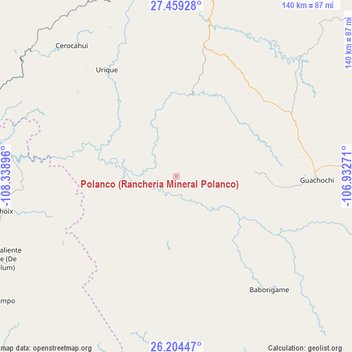
| Upper-left | 27.45928°, | -108.33896° |
| Center: | 26.83361°, | -107.63583° |
| Lower-right: | 26.20447°, | -106.93271° |
| Map W x H: | 139.5×139.5 km | = 86.7×86.7mi |
| max Lat: | 32.7° ⇑3.9% North |
| Polanco (Ranchería Mineral Polanco): | 26.83361° |
| min Lat: | ⇓96.1% South 14.53588° |
| min Long | Polanco (Ranche | max Long |
| -117.105° | -107.63583° | -86.73105° |
| W 4.8%⇐ | ⇒95.2% E |
Elevation
Elevation of Polanco (Ranchería Mineral Polanco) is 1405 m = 4610 ft, and this is 151.3 m = 496 ft above average elevation for this country.
| Max E: |
3497 m = 11473 ft | 50.5% |
| Polanco (Ranchería Mineral Polanco) | 1405 m 4610 ft | |
| Avg. | 1253.7 m = 4113 ft | |
Min E: |
-1 m = -3 ft | 49.5% |
See also: Mexico elevation on elevation.city.
Geographical zone
Polanco (Ranchería Mineral Polanco) is located in North temperate zone (between Tropic of Cancer and the Arctic Circle). Distance of this Northern Tropic circle is 377.7 km =234.7 mi to South.| Distance of | km | miles | from Polanco (Ranchería Mineral Polanco) |
|---|---|---|---|
| North Pole | 7023.4 | 4364.1 | to North |
| Arctic Circle | 4417.6 | 2745 | to North |
| Tropic Cancer | 377.7 | 234.7 | to South |
| Equator | 2983.6 | 1853.9 | to South |


Nearby cities:
15 places around Polanco (Ranchería Mineral Polanco): (largest is in red/bold)
• Agua Caliente Grande (De Gastélum)
78 km =48.5 mi,  245°
245°
• Baborigame
57.9 km =36 mi,  140°
140°
• Bahuichivo
77 km =47.8 mi,  326°
326°
• Bajosori
77 km =47.8 mi,  257°
257°
• Batopilas
24.1 km =15 mi, 334°
• Cerocahui
66.3 km =41.2 mi,  321°
321°
• Choix
69.8 km =43.4 mi, 258°
• Guachochi
55.7 km =34.6 mi,  91°
91°
• Guadalupe
71.9 km =44.7 mi, 250°
• Guapalaina
46.1 km =28.6 mi, 326°
• Morelos
18.3 km =11.4 mi,  192°
192°
• Norogachi
70 km =43.5 mi,  45°
45°
• Samachique
52.9 km =32.9 mi,  10°
10°
• Urique
50.2 km =31.2 mi, 326°
• Yoquivo
23.5 km =14.6 mi,  25°
25°
Sources, notices
• [Note1] Compared only with cities in Mexico existing in our database
• [Src1] Map data: © OpenStreetMap contributors (CC-BY-SA)
• [Src2] Other city data from geonames.org with taken over terms of usage.
• [Src3] Geographical zone / Annual Mean Temperature by Robert A. Rohde @ Wikipedia
