Yoquivo geodata
Yoquivo (Chihuahua) is a populated place; located in Mexico in America/Chihuahua (GMT-6) time zone. With population of 831 people, there are 10527 cities with bigger population in this country. Compared to other cities in Mexico, 96.3% of cities are located further ↓South; 95% of cities are located further →East and 75.4% of cities have lower elevation than Yoquivo. Note1


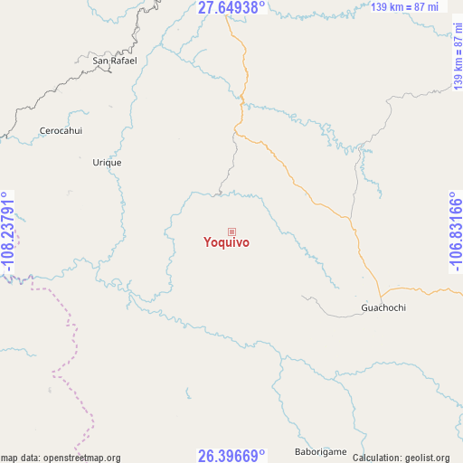
Yoquivo GPS coordinates[2]
27° 1' 29.208" North, 107° 32' 5.208" West
| Map corner | latitude | longitude |
|---|---|---|
| Upper-left | 27.64938°, | -108.23791° |
| Center: | 27.02478°, | -107.53478° |
| Lower-right: | 26.39669°, | -106.83166° |
| Map W x H: | 139.3×139.3 km | = 86.6×86.6mi |
| max Lat: | 32.7° ⇑3.7% North |
| Yoquivo: | 27.02478° |
| min Lat: | ⇓96.3% South 14.53588° |
| min Long | Yoquivo | max Long |
| -117.105° | -107.53478° | -86.73105° |
| W 5%⇐ | ⇒95% E |
Elevation
Elevation of Yoquivo is 2038 m = 6686 ft, and this is 784.3 m = 2573 ft above average elevation for this country.
| Max E: |
3497 m = 11473 ft | 24.6% |
| Yoquivo | 2038 m 6686 ft | |
| Avg. | 1253.7 m = 4113 ft | |
Min E: |
-1 m = -3 ft | 75.4% |
See also: Mexico elevation on elevation.city.
Geographical zone
Yoquivo is located in North temperate zone (between Tropic of Cancer and the Arctic Circle). Distance of this Northern Tropic circle is 399 km =247.9 mi to South.| Distance of | km | miles | from Yoquivo |
|---|---|---|---|
| North Pole | 7002.2 | 4351 | to North |
| Arctic Circle | 4396.3 | 2731.7 | to North |
| Tropic Cancer | 399 | 247.9 | to South |
| Equator | 3004.9 | 1867.2 | to South |


Nearby cities:
15 places around Yoquivo: (largest is in red/bold)
• Baborigame
71.3 km =44.3 mi,  158°
158°
• Bahuichivo
67.8 km =42.1 mi,  309°
309°
• Batopilas
20.5 km =12.7 mi,  271°
271°
• Cerocahui
59.8 km =37.2 mi,  300°
300°
• Creel
81.3 km =50.5 mi,  352°
352°
• Guachochi
51 km =31.7 mi,  116°
116°
• Guapalaina
39.5 km =24.5 mi, 295°
• Morelos
41.6 km =25.8 mi,  199°
199°
• Norogachi
48.7 km =30.3 mi,  55°
55°
• Polanco (Ranchería Mineral Polanco)
23.5 km =14.6 mi,  205°
205°
• Samachique
30.8 km =19.1 mi,  359°
359°
• San Rafael
63.3 km =39.3 mi,  326°
326°
• Sisoguichi
84.4 km =52.4 mi,  2°
2°
• Témoris
78.8 km =49 mi,  290°
290°
• Urique
42.9 km =26.7 mi, 298°
Sources, notices
• [Note1] Compared only with cities in Mexico existing in our database
• [Src1] Map data: © OpenStreetMap contributors (CC-BY-SA)
• [Src2] Other city data from geonames.org with taken over terms of usage.
• [Src3] Geographical zone / Annual Mean Temperature by Robert A. Rohde @ Wikipedia
