El Portezuelo geodata
El Portezuelo (Jalisco) is a populated place; located in Mexico in America/Mexico_City (GMT-6) time zone. With population of 649 people, there are 13347 cities with bigger population in this country. Compared to other cities in Mexico, 70% of cities are located further ↓South; 90.1% of cities are located further →East and 50.8% of cities have higher elevation than El Portezuelo. Note1


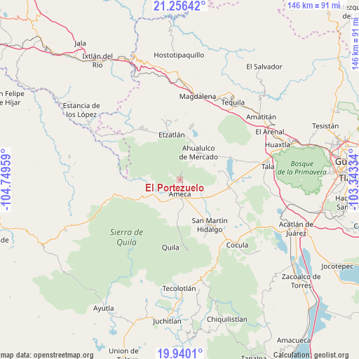
El Portezuelo GPS coordinates[2]
20° 35' 58.848" North, 104° 2' 47.256" West
| Map corner | latitude | longitude |
|---|---|---|
| Upper-left | 21.25642°, | -104.74959° |
| Center: | 20.59968°, | -104.04646° |
| Lower-right: | 19.9401°, | -103.34334° |
| Map W x H: | 146.4×146.4 km | = 91×91mi |
| max Lat: | 32.7° ⇑30% North |
| El Portezuelo: | 20.59968° |
| min Lat: | ⇓70% South 14.53588° |
| min Long | El Portezuelo | max Long |
| -117.105° | -104.04646° | -86.73105° |
| W 9.9%⇐ | ⇒90.1% E |
Elevation
Elevation of El Portezuelo is 1388 m = 4554 ft, and this is 134.3 m = 441 ft above average elevation for this country.
| Max E: |
3497 m = 11473 ft | 50.8% |
| El Portezuelo | 1388 m 4554 ft | |
| Avg. | 1253.7 m = 4113 ft | |
Min E: |
-1 m = -3 ft | 49.2% |
See also: Mexico elevation on elevation.city.
Geographical zone
El Portezuelo is located in North Torrid zone (between Equator and Tropic of Cancer). Distance of this Northern Tropic circle is 315.4 km =196 mi to North.| Distance of | km | miles | from El Portezuelo |
|---|---|---|---|
| North Pole | 7716.6 | 4794.9 | to North |
| Arctic Circle | 5110.7 | 3175.6 | to North |
| Tropic Cancer | 315.4 | 196 | to North |
| Equator | 2290.5 | 1423.3 | to South |


Nearby cities:
15 places around El Portezuelo: (largest is in red/bold)
• Ahualulco de Mercado
13.6 km =8.5 mi,  33°
33°
• Ameca
5.9 km =3.7 mi,  178°
178°
• Buenos Aires
2.6 km =1.6 mi,  141°
141°
• El Amarillo
16.2 km =10.1 mi,  77°
77°
• El Cabezón
15.2 km =9.4 mi, 139°
• El Carmen
15.3 km =9.5 mi,  66°
66°
• Jayamitla
13.8 km =8.6 mi,  265°
265°
• La Estancita
16.1 km =10 mi,  18°
18°
• La Villita
13.2 km =8.2 mi,  263°
263°
• Labor de Solís
7.2 km =4.5 mi,  119°
119°
• Los Pocitos
13.3 km =8.3 mi, 121°
• Portes Gil
13 km =8.1 mi,  59°
59°
• Punta de la Vega
15.5 km =9.6 mi,  93°
93°
• San Nicolás
7.8 km =4.8 mi,  236°
236°
• Santa Cruz de Bárcenas
9 km =5.6 mi, 31°
Sources, notices
• [Note1] Compared only with cities in Mexico existing in our database
• [Src1] Map data: © OpenStreetMap contributors (CC-BY-SA)
• [Src2] Other city data from geonames.org with taken over terms of usage.
• [Src3] Geographical zone / Annual Mean Temperature by Robert A. Rohde @ Wikipedia
